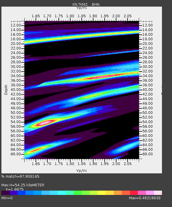
TKM2 KN.TKM2 - Earthquake Result Viewer
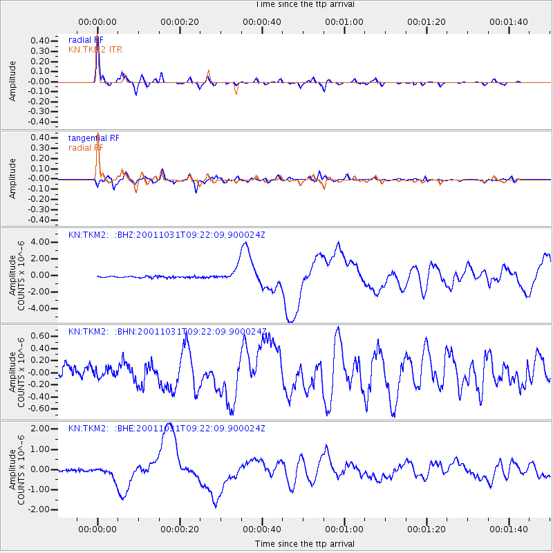
Earthquake location: New Britain Region, P.N.G.
Earthquake latitude/longitude: -5.9/150.2
Earthquake time(UTC): 2001/10/31 (304) 09:10:20 GMT
Earthquake Depth: 33 km
Earthquake Magnitude: 5.9 MB, 6.9 MS, 6.9 MW, 6.9 MW
Earthquake Catalog/Contributor: WHDF/NEIC
Network: KN Kyrgyz Seismic Telemetry Network
Station: TKM2 KN.TKM2
Lat/Lon: 42.92 N/75.60 E
Elevation: 2020 m
Distance: 82.8 deg
Az: 314.458 deg
Baz: 104.857 deg
Ray Param: 0.04656382
Estimated Moho Depth: 54.25 km
Estimated Crust Vp/Vs: 1.69
Assumed Crust Vp: 6.306 km/s
Estimated Crust Vs: 3.737 km/s
Estimated Crust Poisson's Ratio: 0.23
Radial Match: 97.908165 %
Radial Bump: 279
Transverse Match: 91.85657 %
Transverse Bump: 400
SOD ConfigId: 20082
Insert Time: 2010-03-08 20:56:25.044 +0000
GWidth: 2.5
Max Bumps: 400
Tol: 0.001

Signal To Noise

ChannelStoNSTALTA
KN:TKM2: :BHN:20011031T09:22:09.900024Z0.908046367.2225646E-87.95396E-8
KN:TKM2: :BHE:20011031T09:22:09.900024Z7.46107962.930518E-73.92774E-8
KN:TKM2: :BHZ:20011031T09:22:09.900024Z12.320479.591076E-77.784667E-8
Arrivals
Ps6.1 SECOND
PpPs23 SECOND
PsPs/PpSs29 SECOND