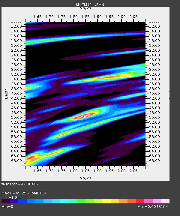
TKM2 KN.TKM2 - Earthquake Result Viewer
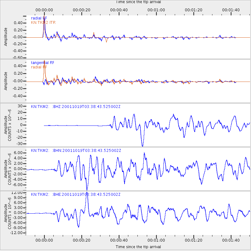
Earthquake location: Banda Sea
Earthquake latitude/longitude: -4.1/123.9
Earthquake time(UTC): 2001/10/19 (292) 03:28:44 GMT
Earthquake Depth: 33 km
Earthquake Magnitude: 6.3 MB, 7.3 MS, 7.5 MW, 7.4 MW
Earthquake Catalog/Contributor: WHDF/NEIC
Network: KN Kyrgyz Seismic Telemetry Network
Station: TKM2 KN.TKM2
Lat/Lon: 42.92 N/75.60 E
Elevation: 2020 m
Distance: 64.0 deg
Az: 322.37 deg
Baz: 123.996 deg
Ray Param: 0.0591851
Estimated Moho Depth: 49.25 km
Estimated Crust Vp/Vs: 1.84
Assumed Crust Vp: 6.306 km/s
Estimated Crust Vs: 3.427 km/s
Estimated Crust Poisson's Ratio: 0.29
Radial Match: 97.88497 %
Radial Bump: 298
Transverse Match: 90.83667 %
Transverse Bump: 400
SOD ConfigId: 20082
Insert Time: 2010-03-08 20:56:26.538 +0000
GWidth: 2.5
Max Bumps: 400
Tol: 0.001

Signal To Noise

ChannelStoNSTALTA
KN:TKM2: :BHN:20011019T03:38:43.525002Z1.49194221.13020256E-77.575378E-8
KN:TKM2: :BHE:20011019T03:38:43.525002Z4.1859342.2096641E-75.2787843E-8
KN:TKM2: :BHZ:20011019T03:38:43.525002Z2.47092633.6929123E-71.4945456E-7
Arrivals
Ps6.8 SECOND
PpPs21 SECOND
PsPs/PpSs28 SECOND