You are here: Home > Network List > TA - USArray Transportable Network (new EarthScope stations) Stations List
> Station H16K Elim, AK, USA > Earthquake Result Viewer
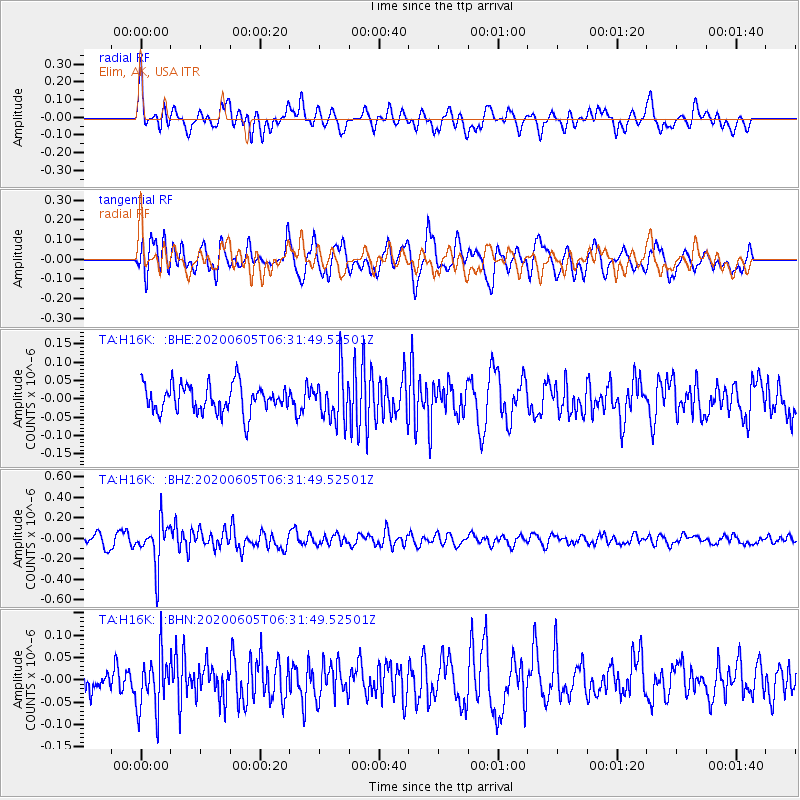
H16K Elim, AK, USA - Earthquake Result Viewer
*The percent match for this event was below the threshold and hence no stack was calculated.
| Earthquake location: |
Tonga Islands Region |
| Earthquake latitude/longitude: |
-22.3/-175.5 |
| Earthquake time(UTC): |
2020/06/05 (157) 06:19:38 GMT |
| Earthquake Depth: |
41 km |
| Earthquake Magnitude: |
5.3 Mww |
| Earthquake Catalog/Contributor: |
NEIC PDE/us |
|
| Network: |
TA USArray Transportable Network (new EarthScope stations) |
| Station: |
H16K Elim, AK, USA |
| Lat/Lon: |
64.64 N/162.24 W |
| Elevation: |
216 m |
|
| Distance: |
87.3 deg |
| Az: |
5.69 deg |
| Baz: |
192.31 deg |
| Ray Param: |
$rayparam |
*The percent match for this event was below the threshold and hence was not used in the summary stack. |
|
| Radial Match: |
67.96198 % |
| Radial Bump: |
400 |
| Transverse Match: |
67.64269 % |
| Transverse Bump: |
400 |
| SOD ConfigId: |
21166931 |
| Insert Time: |
2020-06-19 06:36:45.401 +0000 |
| GWidth: |
2.5 |
| Max Bumps: |
400 |
| Tol: |
0.001 |
|
Signal To Noise
| Channel | StoN | STA | LTA |
| TA:H16K: :BHZ:20200605T06:31:49.52501Z | 4.073047 | 2.1101128E-7 | 5.180674E-8 |
| TA:H16K: :BHN:20200605T06:31:49.52501Z | 2.0132658 | 6.294432E-8 | 3.1264783E-8 |
| TA:H16K: :BHE:20200605T06:31:49.52501Z | 1.6994618 | 6.5304185E-8 | 3.8426393E-8 |
| Arrivals |
| Ps | |
| PpPs | |
| PsPs/PpSs | |


