You are here: Home > Network List > TA - USArray Transportable Network (new EarthScope stations) Stations List
> Station M15K Kasigluk River, AK, USA > Earthquake Result Viewer
M15K Kasigluk River, AK, USA - Earthquake Result Viewer
| Earthquake location: |
Tonga Islands Region |
| Earthquake latitude/longitude: |
-22.3/-175.5 |
| Earthquake time(UTC): |
2020/06/05 (157) 06:19:38 GMT |
| Earthquake Depth: |
41 km |
| Earthquake Magnitude: |
5.3 Mww |
| Earthquake Catalog/Contributor: |
NEIC PDE/us |
|
| Network: |
TA USArray Transportable Network (new EarthScope stations) |
| Station: |
M15K Kasigluk River, AK, USA |
| Lat/Lon: |
60.69 N/160.69 W |
| Elevation: |
210 m |
|
| Distance: |
83.6 deg |
| Az: |
7.287 deg |
| Baz: |
193.814 deg |
| Ray Param: |
0.046033908 |
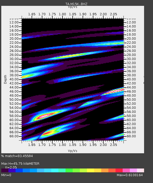
| Estimated Moho Depth: |
45.75 km |
| Estimated Crust Vp/Vs: |
2.05 |
| Assumed Crust Vp: |
6.182 km/s |
| Estimated Crust Vs: |
3.016 km/s |
| Estimated Crust Poisson's Ratio: |
0.34 |
|
| Radial Match: |
83.45594 % |
| Radial Bump: |
400 |
| Transverse Match: |
68.58638 % |
| Transverse Bump: |
400 |
| SOD ConfigId: |
21166931 |
| Insert Time: |
2020-06-19 06:37:19.608 +0000 |
| GWidth: |
2.5 |
| Max Bumps: |
400 |
| Tol: |
0.001 |
|

Signal To Noise
| Channel | StoN | STA | LTA |
| TA:M15K: :BHZ:20200605T06:31:31.199998Z | 10.598551 | 5.782593E-7 | 5.4560225E-8 |
| TA:M15K: :BHN:20200605T06:31:31.199998Z | 4.674104 | 2.0453557E-7 | 4.375931E-8 |
| TA:M15K: :BHE:20200605T06:31:31.199998Z | 1.4213121 | 7.9338335E-8 | 5.5820486E-8 |
| Arrivals |
| Ps | 7.9 SECOND |
| PpPs | 22 SECOND |
| PsPs/PpSs | 30 SECOND |


