You are here: Home > Network List > KN - Kyrgyz Seismic Telemetry Network Stations List
> Station TKM2 KN.TKM2 > Earthquake Result Viewer
TKM2 KN.TKM2 - Earthquake Result Viewer
| Earthquake location: |
Southern Sumatra, Indonesia |
| Earthquake latitude/longitude: |
-4.0/101.7 |
| Earthquake time(UTC): |
2001/01/16 (016) 13:25:01 GMT |
| Earthquake Depth: |
33 km |
| Earthquake Magnitude: |
6.0 MB |
| Earthquake Catalog/Contributor: |
WHDF/NEIC |
|
| Network: |
KN Kyrgyz Seismic Telemetry Network |
| Station: |
TKM2 KN.TKM2 |
| Lat/Lon: |
42.92 N/75.60 E |
| Elevation: |
2020 m |
|
| Distance: |
52.3 deg |
| Az: |
335.853 deg |
| Baz: |
146.249 deg |
| Ray Param: |
0.066777684 |
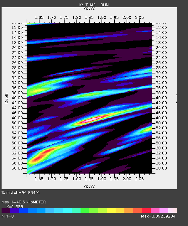
| Estimated Moho Depth: |
48.5 km |
| Estimated Crust Vp/Vs: |
1.86 |
| Assumed Crust Vp: |
6.306 km/s |
| Estimated Crust Vs: |
3.399 km/s |
| Estimated Crust Poisson's Ratio: |
0.30 |
|
| Radial Match: |
96.86491 % |
| Radial Bump: |
400 |
| Transverse Match: |
85.97997 % |
| Transverse Bump: |
400 |
| SOD ConfigId: |
3744 |
| Insert Time: |
2010-03-08 20:57:02.968 +0000 |
| GWidth: |
2.5 |
| Max Bumps: |
400 |
| Tol: |
0.001 |
|
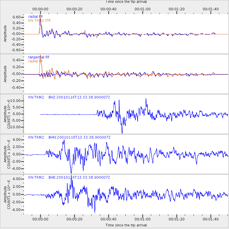
Signal To Noise
| Channel | StoN | STA | LTA |
| KN:TKM2: :BHN:20010116T13:33:38.900007Z | 5.7852974 | 4.114981E-7 | 7.1128255E-8 |
| KN:TKM2: :BHE:20010116T13:33:38.900007Z | 2.8244839 | 2.488574E-7 | 8.8107214E-8 |
| KN:TKM2: :BHZ:20010116T13:33:38.900007Z | 11.271111 | 1.0145772E-6 | 9.0015725E-8 |
| Arrivals |
| Ps | 6.9 SECOND |
| PpPs | 21 SECOND |
| PsPs/PpSs | 28 SECOND |


