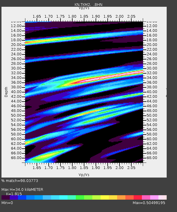
TKM2 KN.TKM2 - Earthquake Result Viewer
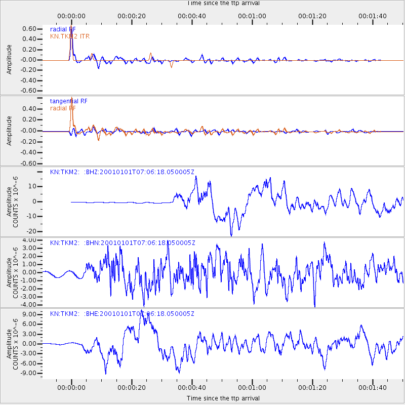
Earthquake location: Mindanao, Philippines
Earthquake latitude/longitude: 6.9/126.6
Earthquake time(UTC): 2001/01/01 (001) 06:57:04 GMT
Earthquake Depth: 33 km
Earthquake Magnitude: 6.4 MB, 7.2 MS, 7.5 MW, 7.3 ME
Earthquake Catalog/Contributor: WHDF/NEIC
Network: KN Kyrgyz Seismic Telemetry Network
Station: TKM2 KN.TKM2
Lat/Lon: 42.92 N/75.60 E
Elevation: 2020 m
Distance: 57.3 deg
Az: 317.301 deg
Baz: 113.567 deg
Ray Param: 0.06351602
Estimated Moho Depth: 34.0 km
Estimated Crust Vp/Vs: 1.91
Assumed Crust Vp: 6.306 km/s
Estimated Crust Vs: 3.293 km/s
Estimated Crust Poisson's Ratio: 0.31
Radial Match: 98.03773 %
Radial Bump: 400
Transverse Match: 81.991974 %
Transverse Bump: 400
SOD ConfigId: 3744
Insert Time: 2010-03-08 20:57:08.423 +0000
GWidth: 2.5
Max Bumps: 400
Tol: 0.001

Signal To Noise

ChannelStoNSTALTA
KN:TKM2: :BHN:20010101T07:06:18.050005Z1.4459234.143863E-72.8658948E-7
KN:TKM2: :BHE:20010101T07:06:18.050005Z4.9942788.139939E-71.629853E-7
KN:TKM2: :BHZ:20010101T07:06:18.050005Z7.22994381.6521129E-62.285098E-7
Arrivals
Ps5.2 SECOND
PpPs15 SECOND
PsPs/PpSs20 SECOND