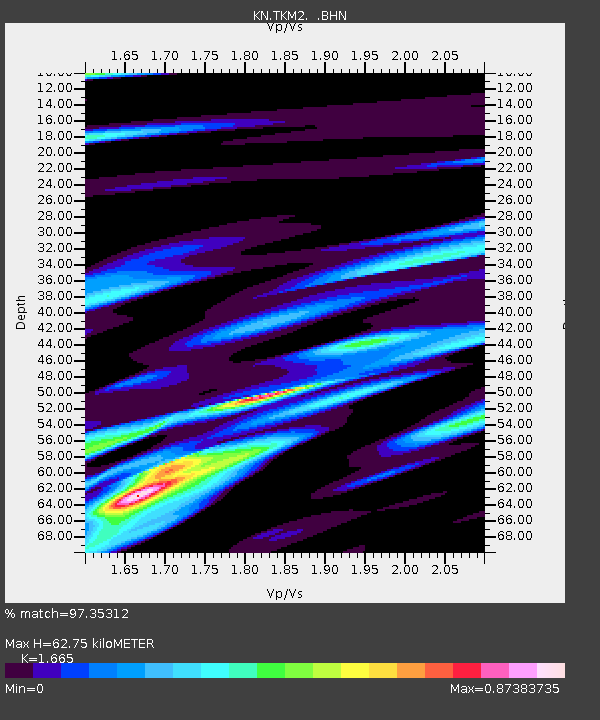
TKM2 KN.TKM2 - Earthquake Result Viewer
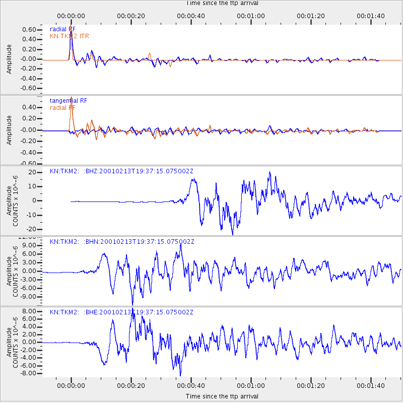
Earthquake location: Southern Sumatra, Indonesia
Earthquake latitude/longitude: -4.7/102.6
Earthquake time(UTC): 2001/02/13 (044) 19:28:30 GMT
Earthquake Depth: 36 km
Earthquake Magnitude: 6.2 MB, 7.2 MS, 7.4 MW, 7.0 ME
Earthquake Catalog/Contributor: WHDF/NEIC
Network: KN Kyrgyz Seismic Telemetry Network
Station: TKM2 KN.TKM2
Lat/Lon: 42.92 N/75.60 E
Elevation: 2020 m
Distance: 53.3 deg
Az: 335.454 deg
Baz: 145.69 deg
Ray Param: 0.06611706
Estimated Moho Depth: 62.75 km
Estimated Crust Vp/Vs: 1.66
Assumed Crust Vp: 6.306 km/s
Estimated Crust Vs: 3.787 km/s
Estimated Crust Poisson's Ratio: 0.22
Radial Match: 97.35312 %
Radial Bump: 372
Transverse Match: 87.73541 %
Transverse Bump: 400
SOD ConfigId: 3744
Insert Time: 2010-03-08 20:57:10.059 +0000
GWidth: 2.5
Max Bumps: 400
Tol: 0.001

Signal To Noise

ChannelStoNSTALTA
KN:TKM2: :BHN:20010213T19:37:15.075002Z1.96779251.6422779E-78.345787E-8
KN:TKM2: :BHE:20010213T19:37:15.075002Z1.02351871.0328589E-71.00912565E-7
KN:TKM2: :BHZ:20010213T19:37:15.075002Z3.02077343.6622217E-71.2123456E-7
Arrivals
Ps7.0 SECOND
PpPs25 SECOND
PsPs/PpSs32 SECOND