You are here: Home > Network List > UW - Pacific Northwest Regional Seismic Network Stations List
> Station IRON Crane, OR, USA > Earthquake Result Viewer
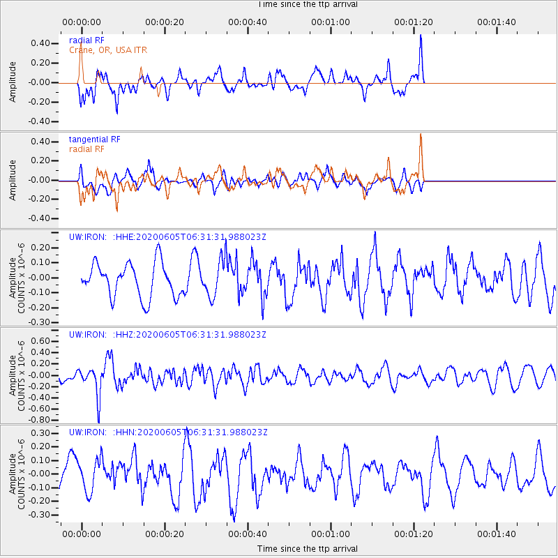
IRON Crane, OR, USA - Earthquake Result Viewer
*The percent match for this event was below the threshold and hence no stack was calculated.
| Earthquake location: |
Tonga Islands Region |
| Earthquake latitude/longitude: |
-22.3/-175.5 |
| Earthquake time(UTC): |
2020/06/05 (157) 06:19:38 GMT |
| Earthquake Depth: |
41 km |
| Earthquake Magnitude: |
5.3 Mww |
| Earthquake Catalog/Contributor: |
NEIC PDE/us |
|
| Network: |
UW Pacific Northwest Regional Seismic Network |
| Station: |
IRON Crane, OR, USA |
| Lat/Lon: |
43.36 N/118.47 W |
| Elevation: |
1226 m |
|
| Distance: |
83.7 deg |
| Az: |
38.01 deg |
| Baz: |
231.436 deg |
| Ray Param: |
$rayparam |
*The percent match for this event was below the threshold and hence was not used in the summary stack. |
|
| Radial Match: |
70.333275 % |
| Radial Bump: |
400 |
| Transverse Match: |
51.403706 % |
| Transverse Bump: |
400 |
| SOD ConfigId: |
21166931 |
| Insert Time: |
2020-06-19 06:40:12.563 +0000 |
| GWidth: |
2.5 |
| Max Bumps: |
400 |
| Tol: |
0.001 |
|
Signal To Noise
| Channel | StoN | STA | LTA |
| UW:IRON: :HHZ:20200605T06:31:31.988023Z | 2.3972836 | 2.5705828E-7 | 1.07228985E-7 |
| UW:IRON: :HHN:20200605T06:31:31.988023Z | 1.3464592 | 1.1805998E-7 | 8.768181E-8 |
| UW:IRON: :HHE:20200605T06:31:31.988023Z | 1.1197946 | 1.2515947E-7 | 1.1177003E-7 |
| Arrivals |
| Ps | |
| PpPs | |
| PsPs/PpSs | |


