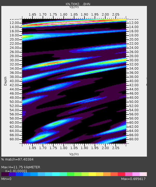
TKM2 KN.TKM2 - Earthquake Result Viewer
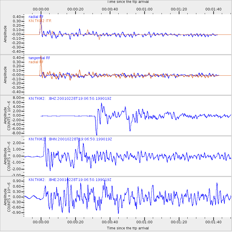
Earthquake location: Washington
Earthquake latitude/longitude: 47.1/-122.7
Earthquake time(UTC): 2001/02/28 (059) 18:54:32 GMT
Earthquake Depth: 52 km
Earthquake Magnitude: 6.5 MB, 6.6 MS, 6.8 MW, 6.7 ME
Earthquake Catalog/Contributor: WHDF/NEIC
Network: KN Kyrgyz Seismic Telemetry Network
Station: TKM2 KN.TKM2
Lat/Lon: 42.92 N/75.60 E
Elevation: 2020 m
Distance: 88.9 deg
Az: 346.645 deg
Baz: 12.393 deg
Ray Param: 0.04218793
Estimated Moho Depth: 11.75 km
Estimated Crust Vp/Vs: 1.81
Assumed Crust Vp: 6.306 km/s
Estimated Crust Vs: 3.484 km/s
Estimated Crust Poisson's Ratio: 0.28
Radial Match: 97.40384 %
Radial Bump: 400
Transverse Match: 90.80995 %
Transverse Bump: 400
SOD ConfigId: 3744
Insert Time: 2010-03-08 20:57:15.239 +0000
GWidth: 2.5
Max Bumps: 400
Tol: 0.001

Signal To Noise

ChannelStoNSTALTA
KN:TKM2: :BHN:20010228T19:06:50.199019Z20.076581.1262595E-65.609817E-8
KN:TKM2: :BHE:20010228T19:06:50.199019Z6.32573372.9123055E-74.6039016E-8
KN:TKM2: :BHZ:20010228T19:06:50.199019Z63.2944683.3195945E-65.2446836E-8
Arrivals
Ps1.5 SECOND
PpPs5.1 SECOND
PsPs/PpSs6.7 SECOND