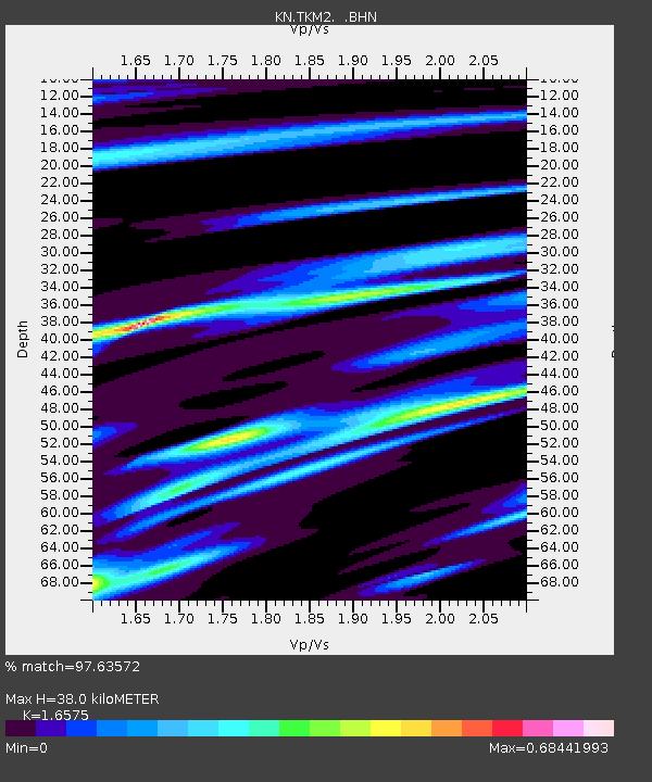
TKM2 KN.TKM2 - Earthquake Result Viewer
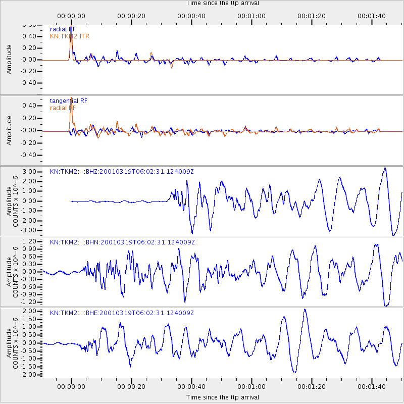
Earthquake location: Banda Sea
Earthquake latitude/longitude: -4.0/128.0
Earthquake time(UTC): 2001/03/19 (078) 05:52:15 GMT
Earthquake Depth: 33 km
Earthquake Magnitude: 6.0 MB, 6.5 MS, 6.5 MW, 6.5 MW
Earthquake Catalog/Contributor: WHDF/NEIC
Network: KN Kyrgyz Seismic Telemetry Network
Station: TKM2 KN.TKM2
Lat/Lon: 42.92 N/75.60 E
Elevation: 2020 m
Distance: 66.5 deg
Az: 320.576 deg
Baz: 120.411 deg
Ray Param: 0.05755436
Estimated Moho Depth: 38.0 km
Estimated Crust Vp/Vs: 1.66
Assumed Crust Vp: 6.306 km/s
Estimated Crust Vs: 3.805 km/s
Estimated Crust Poisson's Ratio: 0.21
Radial Match: 97.63572 %
Radial Bump: 293
Transverse Match: 92.20598 %
Transverse Bump: 400
SOD ConfigId: 4714
Insert Time: 2010-03-08 20:57:19.784 +0000
GWidth: 2.5
Max Bumps: 400
Tol: 0.001

Signal To Noise

ChannelStoNSTALTA
KN:TKM2: :BHN:20010319T06:02:31.124009Z1.64038418.181154E-84.9873407E-8
KN:TKM2: :BHE:20010319T06:02:31.124009Z4.4069231.6672645E-73.783285E-8
KN:TKM2: :BHZ:20010319T06:02:31.124009Z8.4227444.4431994E-75.2752398E-8
Arrivals
Ps4.1 SECOND
PpPs15 SECOND
PsPs/PpSs19 SECOND