You are here: Home > Network List > TA - USArray Transportable Network (new EarthScope stations) Stations List
> Station H19K Roundabout Mountain, AK, USA > Earthquake Result Viewer
H19K Roundabout Mountain, AK, USA - Earthquake Result Viewer
| Earthquake location: |
Fiji Islands |
| Earthquake latitude/longitude: |
-16.6/177.6 |
| Earthquake time(UTC): |
2020/06/06 (158) 10:55:40 GMT |
| Earthquake Depth: |
10 km |
| Earthquake Magnitude: |
5.8 mww |
| Earthquake Catalog/Contributor: |
NEIC PDE/us |
|
| Network: |
TA USArray Transportable Network (new EarthScope stations) |
| Station: |
H19K Roundabout Mountain, AK, USA |
| Lat/Lon: |
65.53 N/156.45 W |
| Elevation: |
107 m |
|
| Distance: |
84.2 deg |
| Az: |
10.573 deg |
| Baz: |
204.982 deg |
| Ray Param: |
0.045644592 |
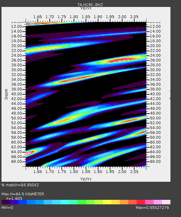
| Estimated Moho Depth: |
64.5 km |
| Estimated Crust Vp/Vs: |
1.61 |
| Assumed Crust Vp: |
6.182 km/s |
| Estimated Crust Vs: |
3.852 km/s |
| Estimated Crust Poisson's Ratio: |
0.18 |
|
| Radial Match: |
84.55042 % |
| Radial Bump: |
395 |
| Transverse Match: |
72.77896 % |
| Transverse Bump: |
400 |
| SOD ConfigId: |
21166931 |
| Insert Time: |
2020-06-20 11:07:41.961 +0000 |
| GWidth: |
2.5 |
| Max Bumps: |
400 |
| Tol: |
0.001 |
|

Signal To Noise
| Channel | StoN | STA | LTA |
| TA:H19K: :BHZ:20200606T11:07:40.925024Z | 0.78564596 | 3.7494445E-8 | 4.7724352E-8 |
| TA:H19K: :BHN:20200606T11:07:40.925024Z | 2.3830218 | 7.192333E-8 | 3.0181567E-8 |
| TA:H19K: :BHE:20200606T11:07:40.925024Z | 1.2943304 | 5.707049E-8 | 4.4092676E-8 |
| Arrivals |
| Ps | 6.5 SECOND |
| PpPs | 26 SECOND |
| PsPs/PpSs | 33 SECOND |


