You are here: Home > Network List > US - United States National Seismic Network Stations List
> Station MNTX Cornudas Mountains, Texas, USA > Earthquake Result Viewer
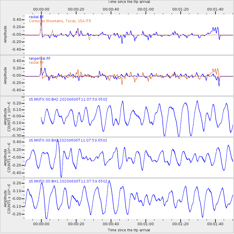
MNTX Cornudas Mountains, Texas, USA - Earthquake Result Viewer
*The percent match for this event was below the threshold and hence no stack was calculated.
| Earthquake location: |
Fiji Islands |
| Earthquake latitude/longitude: |
-16.6/177.6 |
| Earthquake time(UTC): |
2020/06/06 (158) 10:55:40 GMT |
| Earthquake Depth: |
10 km |
| Earthquake Magnitude: |
5.8 mww |
| Earthquake Catalog/Contributor: |
NEIC PDE/us |
|
| Network: |
US United States National Seismic Network |
| Station: |
MNTX Cornudas Mountains, Texas, USA |
| Lat/Lon: |
31.70 N/105.38 W |
| Elevation: |
404 m |
|
| Distance: |
88.0 deg |
| Az: |
56.226 deg |
| Baz: |
249.235 deg |
| Ray Param: |
$rayparam |
*The percent match for this event was below the threshold and hence was not used in the summary stack. |
|
| Radial Match: |
62.298294 % |
| Radial Bump: |
400 |
| Transverse Match: |
49.135685 % |
| Transverse Bump: |
328 |
| SOD ConfigId: |
21166931 |
| Insert Time: |
2020-06-20 11:09:29.459 +0000 |
| GWidth: |
2.5 |
| Max Bumps: |
400 |
| Tol: |
0.001 |
|
Signal To Noise
| Channel | StoN | STA | LTA |
| US:MNTX:00:BHZ:20200606T11:07:59.650Z | 0.8145692 | 1.1573896E-7 | 1.4208611E-7 |
| US:MNTX:00:BH1:20200606T11:07:59.650Z | 2.6279707 | 1.6518855E-7 | 6.2857836E-8 |
| US:MNTX:00:BH2:20200606T11:07:59.650Z | 1.3561859 | 9.840925E-8 | 7.256324E-8 |
| Arrivals |
| Ps | |
| PpPs | |
| PsPs/PpSs | |


