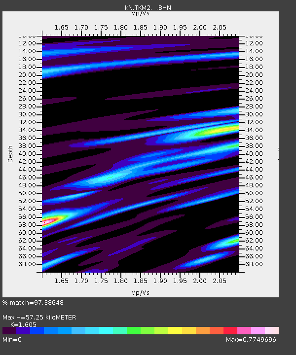
TKM2 KN.TKM2 - Earthquake Result Viewer
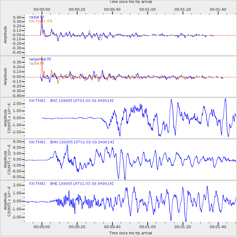
Earthquake location: New Britain Region, P.N.G.
Earthquake latitude/longitude: -4.8/152.5
Earthquake time(UTC): 1999/05/16 (136) 00:51:20 GMT
Earthquake Depth: 74 km
Earthquake Magnitude: 6.0 MB, 7.0 MS, 7.1 MW, 6.3 ME
Earthquake Catalog/Contributor: WHDF/NEIC
Network: KN Kyrgyz Seismic Telemetry Network
Station: TKM2 KN.TKM2
Lat/Lon: 42.92 N/75.60 E
Elevation: 2020 m
Distance: 83.7 deg
Az: 313.961 deg
Baz: 102.424 deg
Ray Param: 0.045873694
Estimated Moho Depth: 57.25 km
Estimated Crust Vp/Vs: 1.61
Assumed Crust Vp: 6.306 km/s
Estimated Crust Vs: 3.929 km/s
Estimated Crust Poisson's Ratio: 0.18
Radial Match: 97.38648 %
Radial Bump: 354
Transverse Match: 93.28475 %
Transverse Bump: 400
SOD ConfigId: 4480
Insert Time: 2010-03-08 20:58:10.774 +0000
GWidth: 2.5
Max Bumps: 400
Tol: 0.001

Signal To Noise

ChannelStoNSTALTA
KN:TKM2: :BHN:19990516T01:03:09.949014Z5.9068013.1758915E-75.376669E-8
KN:TKM2: :BHE:19990516T01:03:09.949014Z1.15088063.5667508E-83.0991494E-8
KN:TKM2: :BHZ:19990516T01:03:09.949014Z1.91515257.9468485E-84.1494598E-8
Arrivals
Ps5.6 SECOND
PpPs23 SECOND
PsPs/PpSs29 SECOND