You are here: Home > Network List > US - United States National Seismic Network Stations List
> Station WMOK Wichita Mountains, Oklahoma, USA > Earthquake Result Viewer
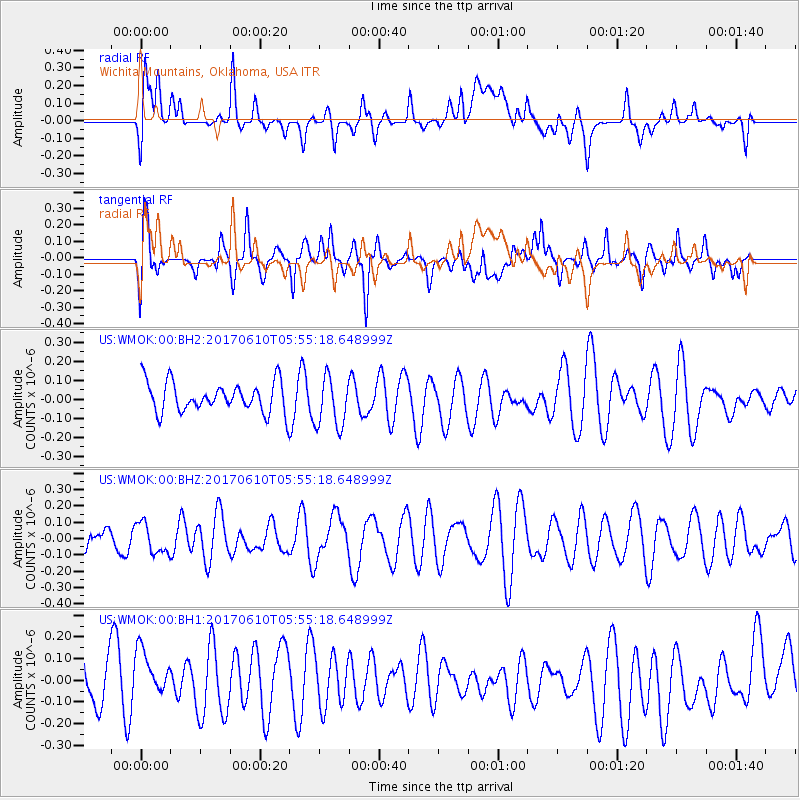
WMOK Wichita Mountains, Oklahoma, USA - Earthquake Result Viewer
*The percent match for this event was below the threshold and hence no stack was calculated.
| Earthquake location: |
Pacific-Antarctic Ridge |
| Earthquake latitude/longitude: |
-54.4/-146.7 |
| Earthquake time(UTC): |
2017/06/10 (161) 05:42:14 GMT |
| Earthquake Depth: |
10 km |
| Earthquake Magnitude: |
5.6 mb |
| Earthquake Catalog/Contributor: |
NEIC PDE/us |
|
| Network: |
US United States National Seismic Network |
| Station: |
WMOK Wichita Mountains, Oklahoma, USA |
| Lat/Lon: |
34.74 N/98.78 W |
| Elevation: |
486 m |
|
| Distance: |
97.9 deg |
| Az: |
38.081 deg |
| Baz: |
205.999 deg |
| Ray Param: |
$rayparam |
*The percent match for this event was below the threshold and hence was not used in the summary stack. |
|
| Radial Match: |
48.06129 % |
| Radial Bump: |
400 |
| Transverse Match: |
67.28511 % |
| Transverse Bump: |
400 |
| SOD ConfigId: |
2140511 |
| Insert Time: |
2017-06-23 21:36:19.046 +0000 |
| GWidth: |
2.5 |
| Max Bumps: |
400 |
| Tol: |
0.001 |
|
Signal To Noise
| Channel | StoN | STA | LTA |
| US:WMOK:00:BHZ:20170610T05:55:18.648999Z | 0.9379403 | 9.267866E-8 | 9.881084E-8 |
| US:WMOK:00:BH1:20170610T05:55:18.648999Z | 1.0648979 | 1.355741E-7 | 1.2731182E-7 |
| US:WMOK:00:BH2:20170610T05:55:18.648999Z | 1.694673 | 1.3366636E-7 | 7.887443E-8 |
| Arrivals |
| Ps | |
| PpPs | |
| PsPs/PpSs | |


