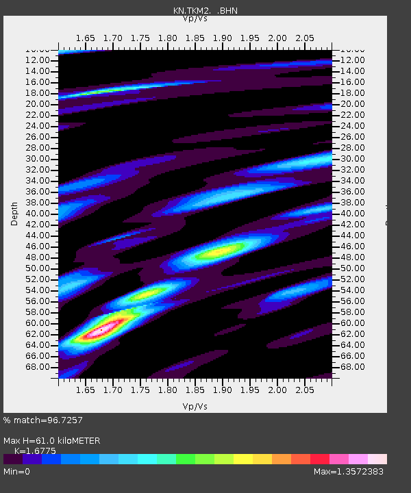
TKM2 KN.TKM2 - Earthquake Result Viewer
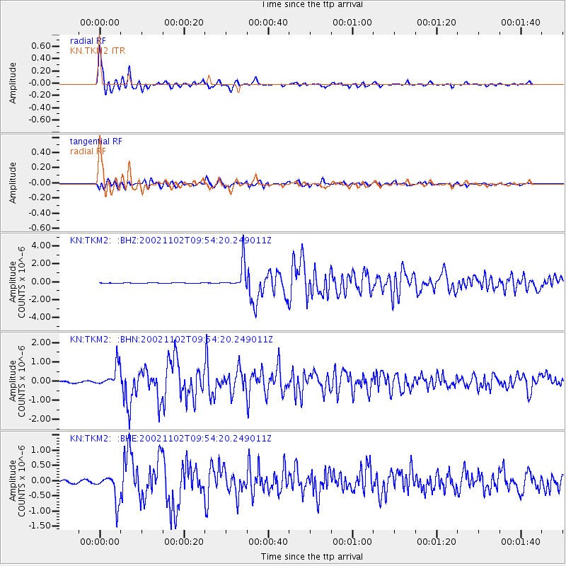
Earthquake location: Northern Sumatra, Indonesia
Earthquake latitude/longitude: 3.0/96.4
Earthquake time(UTC): 2002/11/02 (306) 09:46:46 GMT
Earthquake Depth: 27 km
Earthquake Magnitude: 5.9 MB, 6.4 MS, 6.4 MW, 6.1 MW
Earthquake Catalog/Contributor: WHDF/NEIC
Network: KN Kyrgyz Seismic Telemetry Network
Station: TKM2 KN.TKM2
Lat/Lon: 42.92 N/75.60 E
Elevation: 2020 m
Distance: 43.9 deg
Az: 337.905 deg
Baz: 149.244 deg
Ray Param: 0.07220158
Estimated Moho Depth: 61.0 km
Estimated Crust Vp/Vs: 1.68
Assumed Crust Vp: 6.306 km/s
Estimated Crust Vs: 3.759 km/s
Estimated Crust Poisson's Ratio: 0.22
Radial Match: 96.7257 %
Radial Bump: 326
Transverse Match: 87.75653 %
Transverse Bump: 400
SOD ConfigId: 4714
Insert Time: 2010-03-08 20:59:43.135 +0000
GWidth: 2.5
Max Bumps: 400
Tol: 0.001

Signal To Noise

ChannelStoNSTALTA
KN:TKM2: :BHN:20021102T09:54:20.249011Z12.8284175.959082E-74.64522E-8
KN:TKM2: :BHE:20021102T09:54:20.249011Z8.7783964.6888252E-75.341324E-8
KN:TKM2: :BHZ:20021102T09:54:20.249011Z46.7887881.5116259E-63.2307437E-8
Arrivals
Ps7.0 SECOND
PpPs24 SECOND
PsPs/PpSs31 SECOND