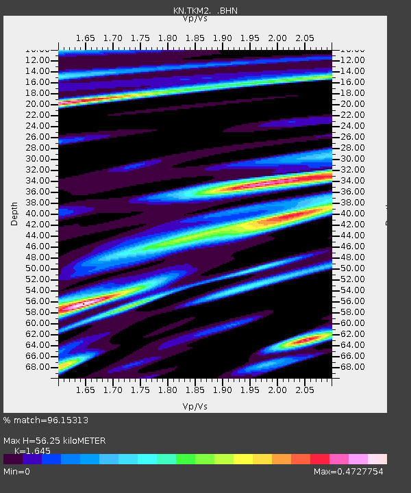
TKM2 KN.TKM2 - Earthquake Result Viewer
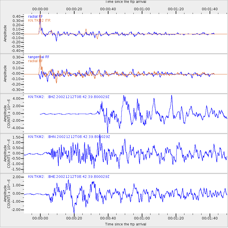
Earthquake location: New Ireland Region, P.N.G.
Earthquake latitude/longitude: -4.8/153.3
Earthquake time(UTC): 2002/12/12 (346) 08:30:42 GMT
Earthquake Depth: 34 km
Earthquake Magnitude: 5.9 MB, 6.7 MS, 6.7 MW, 6.6 MW
Earthquake Catalog/Contributor: WHDF/NEIC
Network: KN Kyrgyz Seismic Telemetry Network
Station: TKM2 KN.TKM2
Lat/Lon: 42.92 N/75.60 E
Elevation: 2020 m
Distance: 84.3 deg
Az: 313.841 deg
Baz: 101.901 deg
Ray Param: 0.04556365
Estimated Moho Depth: 56.25 km
Estimated Crust Vp/Vs: 1.64
Assumed Crust Vp: 6.306 km/s
Estimated Crust Vs: 3.833 km/s
Estimated Crust Poisson's Ratio: 0.21
Radial Match: 96.15313 %
Radial Bump: 400
Transverse Match: 89.54321 %
Transverse Bump: 400
SOD ConfigId: 4714
Insert Time: 2010-03-08 20:59:44.520 +0000
GWidth: 2.5
Max Bumps: 400
Tol: 0.001

Signal To Noise

ChannelStoNSTALTA
KN:TKM2: :BHN:20021212T08:42:39.800029Z1.04098868.375195E-88.045424E-8
KN:TKM2: :BHE:20021212T08:42:39.800029Z0.71260084.4145526E-86.194987E-8
KN:TKM2: :BHZ:20021212T08:42:39.800029Z3.61639862.4408376E-76.74936E-8
Arrivals
Ps5.9 SECOND
PpPs23 SECOND
PsPs/PpSs29 SECOND