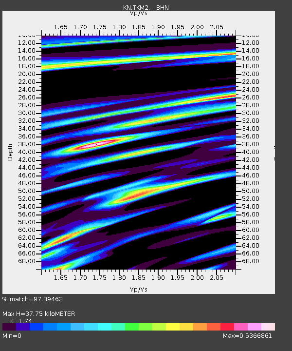
TKM2 KN.TKM2 - Earthquake Result Viewer
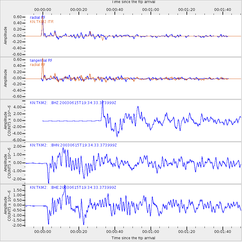
Earthquake location: Rat Islands, Aleutian Islands
Earthquake latitude/longitude: 51.6/176.9
Earthquake time(UTC): 2003/06/15 (166) 19:24:33 GMT
Earthquake Depth: 20 km
Earthquake Magnitude: 6.0 MB, 6.4 MS, 6.5 MW, 6.5 MW
Earthquake Catalog/Contributor: WHDF/NEIC
Network: KN Kyrgyz Seismic Telemetry Network
Station: TKM2 KN.TKM2
Lat/Lon: 42.92 N/75.60 E
Elevation: 2020 m
Distance: 63.9 deg
Az: 306.673 deg
Baz: 42.979 deg
Ray Param: 0.059253026
Estimated Moho Depth: 37.75 km
Estimated Crust Vp/Vs: 1.74
Assumed Crust Vp: 6.306 km/s
Estimated Crust Vs: 3.624 km/s
Estimated Crust Poisson's Ratio: 0.25
Radial Match: 97.39463 %
Radial Bump: 344
Transverse Match: 91.14742 %
Transverse Bump: 400
SOD ConfigId: 4714
Insert Time: 2010-03-08 20:59:58.559 +0000
GWidth: 2.5
Max Bumps: 400
Tol: 0.001

Signal To Noise

ChannelStoNSTALTA
KN:TKM2: :BHN:20030615T19:34:33.373999Z40.4042478.2044795E-72.0305983E-8
KN:TKM2: :BHE:20030615T19:34:33.373999Z30.1079756.603866E-72.193394E-8
KN:TKM2: :BHZ:20030615T19:34:33.373999Z59.1062852.0406628E-63.452531E-8
Arrivals
Ps4.6 SECOND
PpPs16 SECOND
PsPs/PpSs20 SECOND