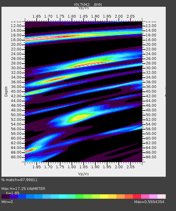
TKM2 KN.TKM2 - Earthquake Result Viewer
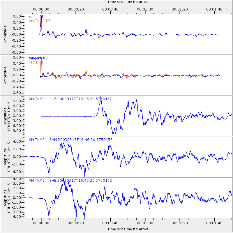
Earthquake location: Rat Islands, Aleutian Islands
Earthquake latitude/longitude: 51.3/178.0
Earthquake time(UTC): 2003/03/17 (076) 16:36:17 GMT
Earthquake Depth: 33 km
Earthquake Magnitude: 5.9 MB, 6.7 MS, 7.0 MW, 7.0 MW
Earthquake Catalog/Contributor: WHDF/NEIC
Network: KN Kyrgyz Seismic Telemetry Network
Station: TKM2 KN.TKM2
Lat/Lon: 42.92 N/75.60 E
Elevation: 2020 m
Distance: 64.6 deg
Az: 307.412 deg
Baz: 42.785 deg
Ray Param: 0.058768734
Estimated Moho Depth: 17.25 km
Estimated Crust Vp/Vs: 1.65
Assumed Crust Vp: 6.306 km/s
Estimated Crust Vs: 3.822 km/s
Estimated Crust Poisson's Ratio: 0.21
Radial Match: 97.99811 %
Radial Bump: 307
Transverse Match: 91.66731 %
Transverse Bump: 400
SOD ConfigId: 4714
Insert Time: 2010-03-08 21:00:06.265 +0000
GWidth: 2.5
Max Bumps: 400
Tol: 0.001

Signal To Noise

ChannelStoNSTALTA
KN:TKM2: :BHN:20030317T16:46:20.575015Z14.8441431.7994905E-61.2122563E-7
KN:TKM2: :BHE:20030317T16:46:20.575015Z19.5852471.545559E-67.8914454E-8
KN:TKM2: :BHZ:20030317T16:46:20.575015Z62.336514.9450628E-67.9328515E-8
Arrivals
Ps1.9 SECOND
PpPs6.9 SECOND
PsPs/PpSs8.8 SECOND