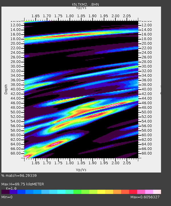
TKM2 KN.TKM2 - Earthquake Result Viewer
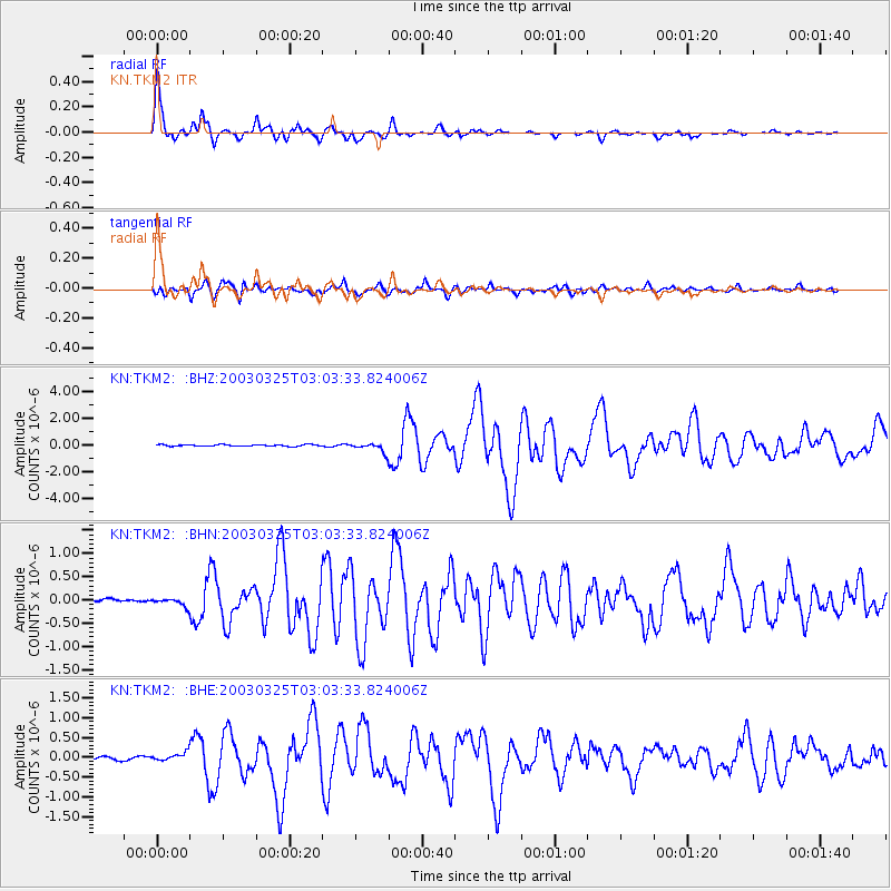
Earthquake location: Flores Region, Indonesia
Earthquake latitude/longitude: -8.3/120.7
Earthquake time(UTC): 2003/03/25 (084) 02:53:25 GMT
Earthquake Depth: 33 km
Earthquake Magnitude: 6.2 MB, 6.1 MS, 6.5 MW, 6.3 MW
Earthquake Catalog/Contributor: WHDF/NEIC
Network: KN Kyrgyz Seismic Telemetry Network
Station: TKM2 KN.TKM2
Lat/Lon: 42.92 N/75.60 E
Elevation: 2020 m
Distance: 65.4 deg
Az: 325.075 deg
Baz: 129.527 deg
Ray Param: 0.058211826
Estimated Moho Depth: 69.75 km
Estimated Crust Vp/Vs: 1.60
Assumed Crust Vp: 6.306 km/s
Estimated Crust Vs: 3.941 km/s
Estimated Crust Poisson's Ratio: 0.18
Radial Match: 96.29339 %
Radial Bump: 333
Transverse Match: 89.87657 %
Transverse Bump: 400
SOD ConfigId: 4714
Insert Time: 2010-03-08 21:00:26.404 +0000
GWidth: 2.5
Max Bumps: 400
Tol: 0.001

Signal To Noise

ChannelStoNSTALTA
KN:TKM2: :BHN:20030325T03:03:33.824006Z1.39146247.4854015E-85.379521E-8
KN:TKM2: :BHE:20030325T03:03:33.824006Z2.49800011.07030104E-74.2846317E-8
KN:TKM2: :BHZ:20030325T03:03:33.824006Z6.0104753.4566787E-75.751091E-8
Arrivals
Ps6.9 SECOND
PpPs28 SECOND
PsPs/PpSs34 SECOND