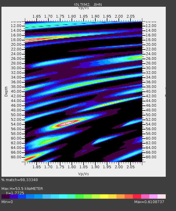
TKM2 KN.TKM2 - Earthquake Result Viewer
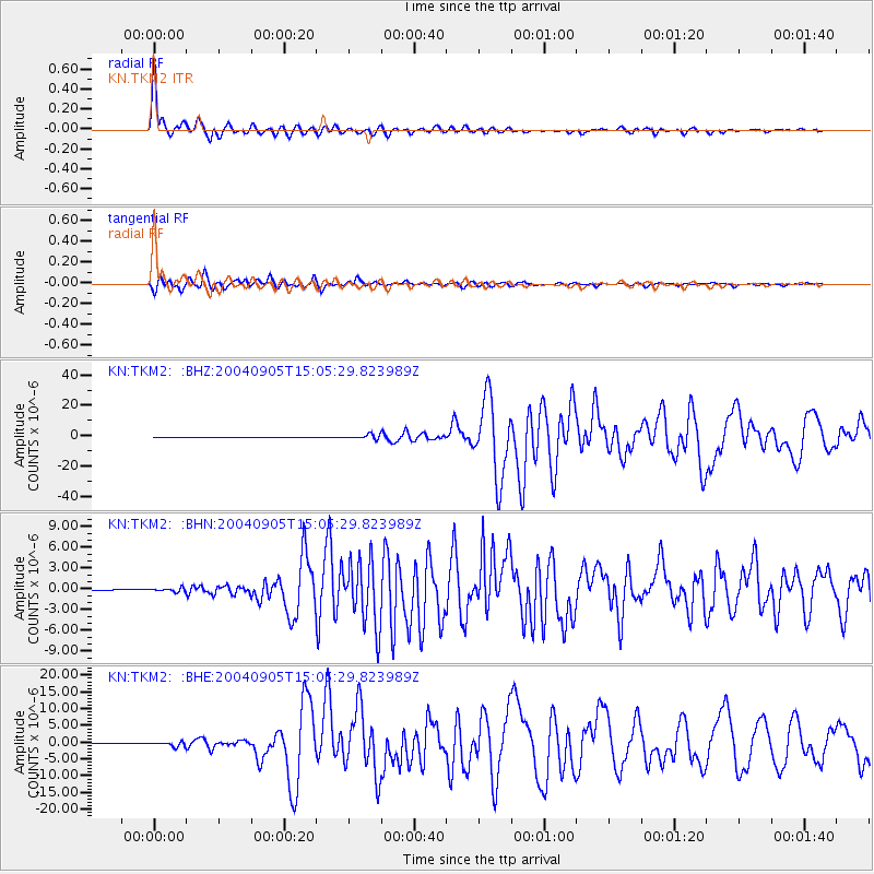
Earthquake location: Near S. Coast Of Honshu, Japan
Earthquake latitude/longitude: 33.2/137.1
Earthquake time(UTC): 2004/09/05 (249) 14:57:18 GMT
Earthquake Depth: 10 km
Earthquake Magnitude: 6.2 MB, 7.1 MS, 7.4 MW, 7.4 MW
Earthquake Catalog/Contributor: WHDF/NEIC
Network: KN Kyrgyz Seismic Telemetry Network
Station: TKM2 KN.TKM2
Lat/Lon: 42.92 N/75.60 E
Elevation: 2020 m
Distance: 48.4 deg
Az: 300.351 deg
Baz: 80.112 deg
Ray Param: 0.069381714
Estimated Moho Depth: 53.5 km
Estimated Crust Vp/Vs: 1.77
Assumed Crust Vp: 6.306 km/s
Estimated Crust Vs: 3.558 km/s
Estimated Crust Poisson's Ratio: 0.27
Radial Match: 98.33348 %
Radial Bump: 323
Transverse Match: 92.57255 %
Transverse Bump: 400
SOD ConfigId: 2459
Insert Time: 2010-03-08 21:01:06.969 +0000
GWidth: 2.5
Max Bumps: 400
Tol: 0.001

Signal To Noise

ChannelStoNSTALTA
KN:TKM2: :BHN:20040905T15:05:29.823989Z5.72442252.721817E-74.754745E-8
KN:TKM2: :BHE:20040905T15:05:29.823989Z13.5863366.829319E-75.026608E-8
KN:TKM2: :BHZ:20040905T15:05:29.823989Z33.1252251.5200521E-64.588805E-8
Arrivals
Ps6.9 SECOND
PpPs22 SECOND
PsPs/PpSs29 SECOND