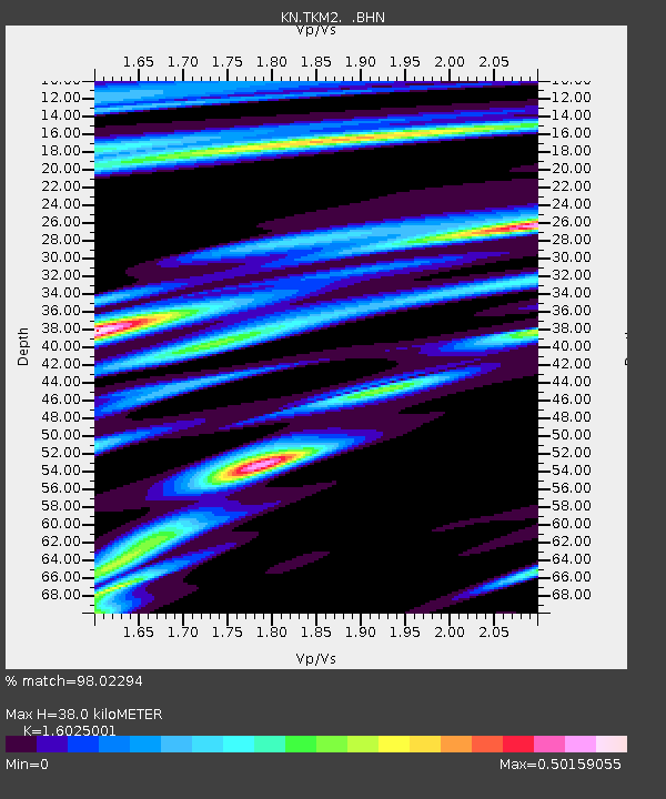
TKM2 KN.TKM2 - Earthquake Result Viewer
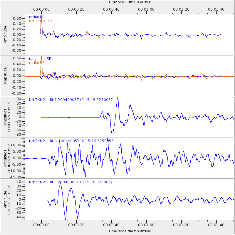
Earthquake location: Near S. Coast Of Western Honshu
Earthquake latitude/longitude: 33.1/136.6
Earthquake time(UTC): 2004/09/05 (249) 10:07:07 GMT
Earthquake Depth: 14 km
Earthquake Magnitude: 6.7 MB, 7.0 MS, 7.2 MW, 7.0 MW
Earthquake Catalog/Contributor: WHDF/NEIC
Network: KN Kyrgyz Seismic Telemetry Network
Station: TKM2 KN.TKM2
Lat/Lon: 42.92 N/75.60 E
Elevation: 2020 m
Distance: 48.1 deg
Az: 300.364 deg
Baz: 80.501 deg
Ray Param: 0.069540106
Estimated Moho Depth: 38.0 km
Estimated Crust Vp/Vs: 1.60
Assumed Crust Vp: 6.306 km/s
Estimated Crust Vs: 3.935 km/s
Estimated Crust Poisson's Ratio: 0.18
Radial Match: 98.02294 %
Radial Bump: 262
Transverse Match: 95.40366 %
Transverse Bump: 400
SOD ConfigId: 2459
Insert Time: 2010-03-08 21:01:09.502 +0000
GWidth: 2.5
Max Bumps: 400
Tol: 0.001

Signal To Noise

ChannelStoNSTALTA
KN:TKM2: :BHN:20040905T10:15:16.325005Z31.2932971.2059021E-63.8535475E-8
KN:TKM2: :BHE:20040905T10:15:16.325005Z67.484083.7622742E-65.5750544E-8
KN:TKM2: :BHZ:20040905T10:15:16.325005Z109.4932258.071146E-67.371366E-8
Arrivals
Ps3.9 SECOND
PpPs15 SECOND
PsPs/PpSs19 SECOND