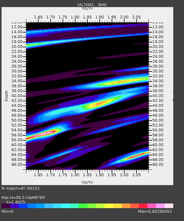
TKM2 KN.TKM2 - Earthquake Result Viewer
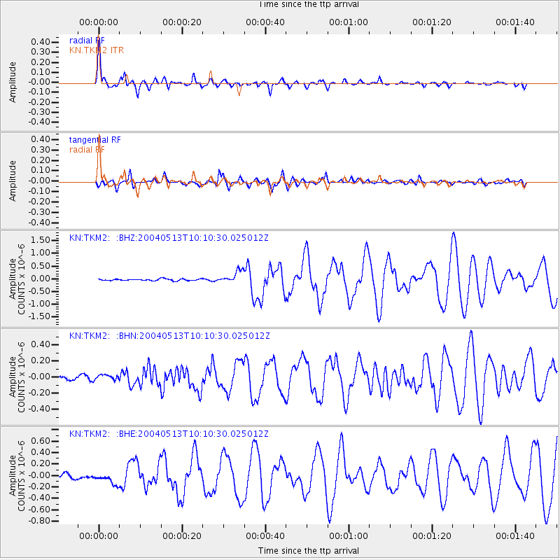
Earthquake location: New Ireland Region, P.N.G.
Earthquake latitude/longitude: -3.6/150.7
Earthquake time(UTC): 2004/05/13 (134) 09:58:43 GMT
Earthquake Depth: 10 km
Earthquake Magnitude: 5.8 MB, 6.3 MS, 6.3 MW, 6.2 MW
Earthquake Catalog/Contributor: WHDF/NEIC
Network: KN Kyrgyz Seismic Telemetry Network
Station: TKM2 KN.TKM2
Lat/Lon: 42.92 N/75.60 E
Elevation: 2020 m
Distance: 81.6 deg
Az: 314.138 deg
Baz: 102.811 deg
Ray Param: 0.047468252
Estimated Moho Depth: 55.0 km
Estimated Crust Vp/Vs: 1.68
Assumed Crust Vp: 6.306 km/s
Estimated Crust Vs: 3.748 km/s
Estimated Crust Poisson's Ratio: 0.23
Radial Match: 97.98153 %
Radial Bump: 400
Transverse Match: 90.989006 %
Transverse Bump: 400
SOD ConfigId: 2459
Insert Time: 2010-03-08 21:01:22.426 +0000
GWidth: 2.5
Max Bumps: 400
Tol: 0.001

Signal To Noise

ChannelStoNSTALTA
KN:TKM2: :BHN:20040513T10:10:30.025012Z1.40823733.8823718E-82.7569017E-8
KN:TKM2: :BHE:20040513T10:10:30.025012Z3.42721.0439707E-73.046133E-8
KN:TKM2: :BHZ:20040513T10:10:30.025012Z7.7592822.5076946E-73.231864E-8
Arrivals
Ps6.1 SECOND
PpPs23 SECOND
PsPs/PpSs29 SECOND