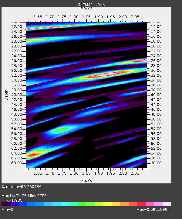
TKM2 KN.TKM2 - Earthquake Result Viewer
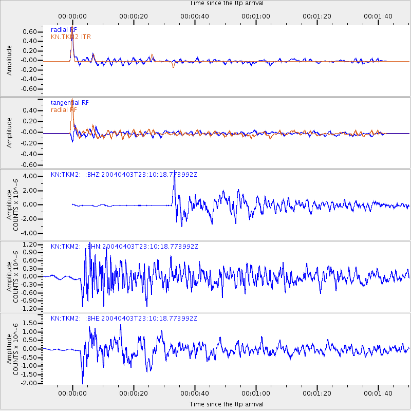
Earthquake location: Near East Coast Of Honshu, Japan
Earthquake latitude/longitude: 36.4/141.0
Earthquake time(UTC): 2004/04/03 (094) 23:02:00 GMT
Earthquake Depth: 31 km
Earthquake Magnitude: 5.7 MB, 5.6 MS, 6.0 MW, 5.9 MW
Earthquake Catalog/Contributor: WHDF/NEIC
Network: KN Kyrgyz Seismic Telemetry Network
Station: TKM2 KN.TKM2
Lat/Lon: 42.92 N/75.60 E
Elevation: 2020 m
Distance: 49.6 deg
Az: 298.755 deg
Baz: 74.267 deg
Ray Param: 0.06851988
Estimated Moho Depth: 31.25 km
Estimated Crust Vp/Vs: 1.93
Assumed Crust Vp: 6.306 km/s
Estimated Crust Vs: 3.259 km/s
Estimated Crust Poisson's Ratio: 0.32
Radial Match: 96.250786 %
Radial Bump: 381
Transverse Match: 89.977974 %
Transverse Bump: 400
SOD ConfigId: 2459
Insert Time: 2010-03-08 21:01:29.646 +0000
GWidth: 2.5
Max Bumps: 400
Tol: 0.001

Signal To Noise

ChannelStoNSTALTA
KN:TKM2: :BHN:20040403T23:10:18.773992Z10.3662233.9310072E-73.7921307E-8
KN:TKM2: :BHE:20040403T23:10:18.773992Z12.1542315.655035E-74.6527294E-8
KN:TKM2: :BHZ:20040403T23:10:18.773992Z23.7729761.3595342E-65.7188217E-8
Arrivals
Ps4.9 SECOND
PpPs14 SECOND
PsPs/PpSs19 SECOND