You are here: Home > Network List > TA - USArray Transportable Network (new EarthScope stations) Stations List
> Station D23K Nanushuk River, AK USA > Earthquake Result Viewer
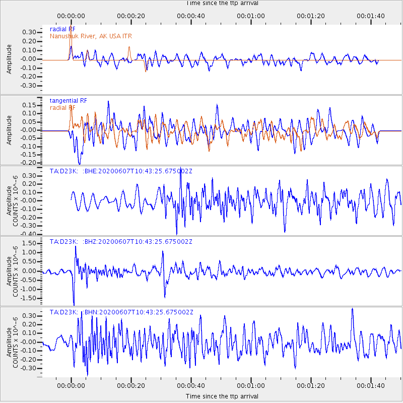
D23K Nanushuk River, AK USA - Earthquake Result Viewer
*The percent match for this event was below the threshold and hence no stack was calculated.
| Earthquake location: |
Northern Peru |
| Earthquake latitude/longitude: |
-4.0/-76.9 |
| Earthquake time(UTC): |
2020/06/07 (159) 10:31:17 GMT |
| Earthquake Depth: |
99 km |
| Earthquake Magnitude: |
5.4 Mww |
| Earthquake Catalog/Contributor: |
NEIC PDE/us |
|
| Network: |
TA USArray Transportable Network (new EarthScope stations) |
| Station: |
D23K Nanushuk River, AK USA |
| Lat/Lon: |
68.97 N/150.68 W |
| Elevation: |
406 m |
|
| Distance: |
88.0 deg |
| Az: |
339.708 deg |
| Baz: |
106.615 deg |
| Ray Param: |
$rayparam |
*The percent match for this event was below the threshold and hence was not used in the summary stack. |
|
| Radial Match: |
63.219807 % |
| Radial Bump: |
400 |
| Transverse Match: |
74.27777 % |
| Transverse Bump: |
400 |
| SOD ConfigId: |
21166931 |
| Insert Time: |
2020-06-21 10:56:13.260 +0000 |
| GWidth: |
2.5 |
| Max Bumps: |
400 |
| Tol: |
0.001 |
|
Signal To Noise
| Channel | StoN | STA | LTA |
| TA:D23K: :BHZ:20200607T10:43:25.675002Z | 6.2500234 | 6.15391E-7 | 9.8462195E-8 |
| TA:D23K: :BHN:20200607T10:43:25.675002Z | 2.0474818 | 1.6053869E-7 | 7.840787E-8 |
| TA:D23K: :BHE:20200607T10:43:25.675002Z | 1.3367798 | 9.955756E-8 | 7.447566E-8 |
| Arrivals |
| Ps | |
| PpPs | |
| PsPs/PpSs | |


