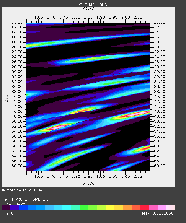
TKM2 KN.TKM2 - Earthquake Result Viewer
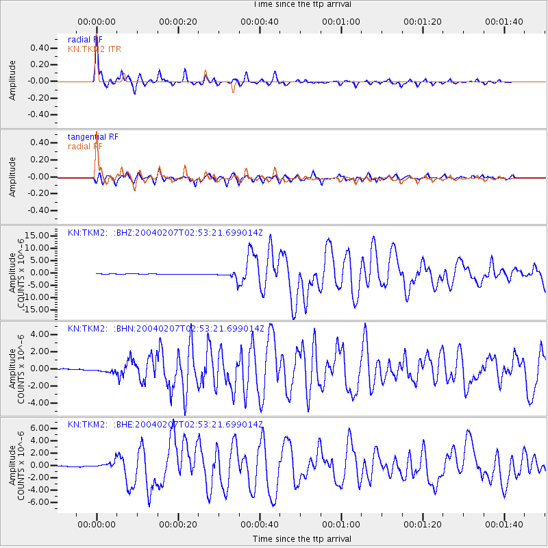
Earthquake location: Irian Jaya Region, Indonesia
Earthquake latitude/longitude: -4.0/135.0
Earthquake time(UTC): 2004/02/07 (038) 02:42:35 GMT
Earthquake Depth: 10 km
Earthquake Magnitude: 6.2 MB, 7.5 MS, 7.3 MW, 7.3 MW
Earthquake Catalog/Contributor: WHDF/NEIC
Network: KN Kyrgyz Seismic Telemetry Network
Station: TKM2 KN.TKM2
Lat/Lon: 42.92 N/75.60 E
Elevation: 2020 m
Distance: 71.0 deg
Az: 318.016 deg
Baz: 114.71 deg
Ray Param: 0.05461504
Estimated Moho Depth: 46.75 km
Estimated Crust Vp/Vs: 2.04
Assumed Crust Vp: 6.306 km/s
Estimated Crust Vs: 3.087 km/s
Estimated Crust Poisson's Ratio: 0.34
Radial Match: 97.558304 %
Radial Bump: 259
Transverse Match: 91.36658 %
Transverse Bump: 400
SOD ConfigId: 2459
Insert Time: 2010-03-08 21:01:40.153 +0000
GWidth: 2.5
Max Bumps: 400
Tol: 0.001

Signal To Noise

ChannelStoNSTALTA
KN:TKM2: :BHN:20040207T02:53:21.699014Z3.7305772.5061524E-76.717868E-8
KN:TKM2: :BHE:20040207T02:53:21.699014Z13.25982955.593504E-74.2183828E-8
KN:TKM2: :BHZ:20040207T02:53:21.699014Z19.033651.6799555E-68.8262404E-8
Arrivals
Ps8.0 SECOND
PpPs22 SECOND
PsPs/PpSs30 SECOND