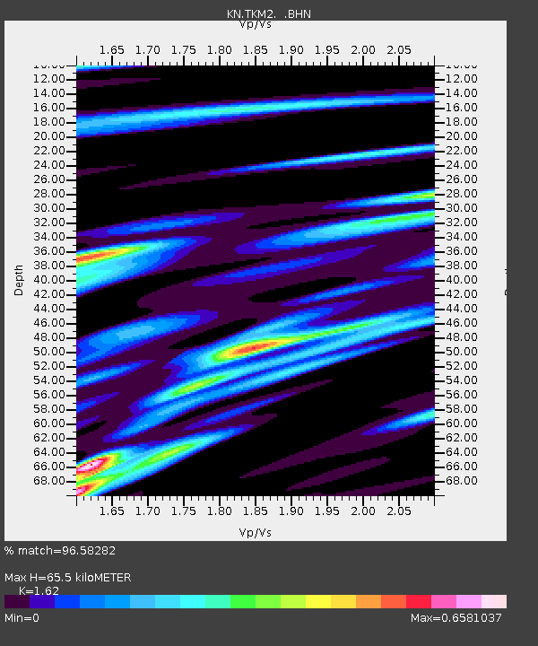
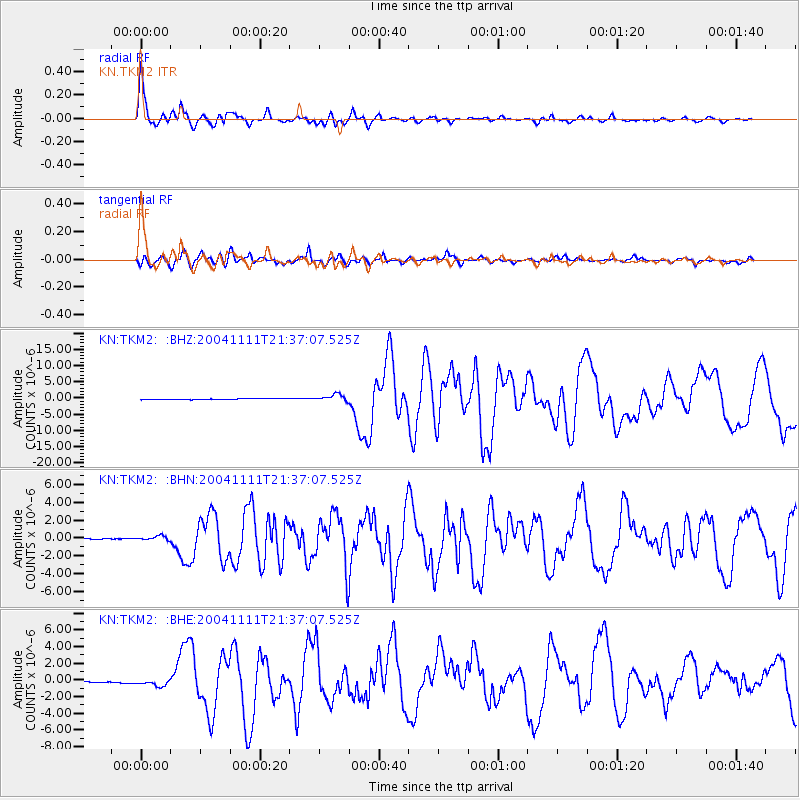
TKM2 KN.TKM2 - Earthquake Result Viewer

Earthquake location: Timor Region
Earthquake latitude/longitude: -8.2/124.9
Earthquake time(UTC): 2004/11/11 (316) 21:26:41 GMT
Earthquake Depth: 10 km
Earthquake Magnitude: 6.5 MB, 7.3 MS, 7.5 MW, 7.4 MW
Earthquake Catalog/Contributor: WHDF/NEIC
Network: KN Kyrgyz Seismic Telemetry Network
Station: TKM2 KN.TKM2
Lat/Lon: 42.92 N/75.60 E
Elevation: 2020 m
Distance: 67.7 deg
Az: 323.021 deg
Baz: 125.835 deg
Ray Param: 0.05676432
Estimated Moho Depth: 65.5 km
Estimated Crust Vp/Vs: 1.62
Assumed Crust Vp: 6.306 km/s
Estimated Crust Vs: 3.893 km/s
Estimated Crust Poisson's Ratio: 0.19
Radial Match: 96.58282 %
Radial Bump: 400
Transverse Match: 87.75333 %
Transverse Bump: 400
SOD ConfigId: 2459
Insert Time: 2010-03-08 21:02:02.535 +0000
GWidth: 2.5
Max Bumps: 400
Tol: 0.001

Signal To Noise

ChannelStoNSTALTA
KN:TKM2: :BHN:20041111T21:37:07.525Z3.49534582.9900295E-78.554317E-8
KN:TKM2: :BHE:20041111T21:37:07.525Z5.64984564.5260904E-78.0109984E-8
KN:TKM2: :BHZ:20041111T21:37:07.525Z6.30454351.0342433E-61.640473E-7
Arrivals
Ps6.7 SECOND
PpPs26 SECOND
PsPs/PpSs33 SECOND