You are here: Home > Network List > TS - TERRAscope (Southern California Seismic Network) Stations List
> Station USC USC, Los Angeles, California, USA > Earthquake Result Viewer
USC USC, Los Angeles, California, USA - Earthquake Result Viewer
| Earthquake location: |
Windward Islands |
| Earthquake latitude/longitude: |
11.1/-60.9 |
| Earthquake time(UTC): |
1997/04/22 (112) 09:31:23 GMT |
| Earthquake Depth: |
5.0 km |
| Earthquake Magnitude: |
6.0 MB, 6.5 MS, 6.7 UNKNOWN, 6.1 ME |
| Earthquake Catalog/Contributor: |
WHDF/NEIC |
|
| Network: |
TS TERRAscope (Southern California Seismic Network) |
| Station: |
USC USC, Los Angeles, California, USA |
| Lat/Lon: |
34.02 N/118.29 W |
| Elevation: |
60 m |
|
| Distance: |
56.9 deg |
| Az: |
303.375 deg |
| Baz: |
99.307 deg |
| Ray Param: |
0.06384214 |
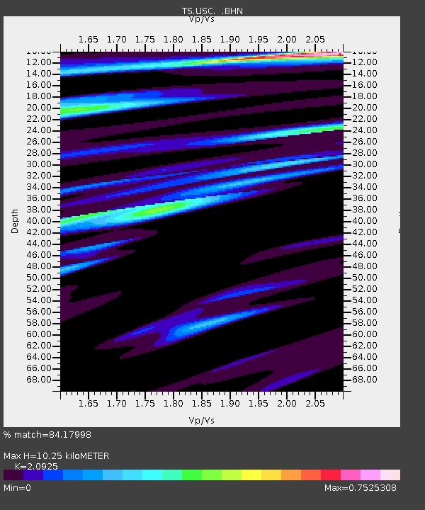
| Estimated Moho Depth: |
10.25 km |
| Estimated Crust Vp/Vs: |
2.09 |
| Assumed Crust Vp: |
6.1 km/s |
| Estimated Crust Vs: |
2.915 km/s |
| Estimated Crust Poisson's Ratio: |
0.35 |
|
| Radial Match: |
84.17998 % |
| Radial Bump: |
400 |
| Transverse Match: |
69.76437 % |
| Transverse Bump: |
400 |
| SOD ConfigId: |
6273 |
| Insert Time: |
2010-02-26 14:53:12.317 +0000 |
| GWidth: |
2.5 |
| Max Bumps: |
400 |
| Tol: |
0.001 |
|
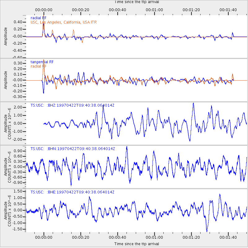
Signal To Noise
| Channel | StoN | STA | LTA |
| TS:USC: :BHN:19970422T09:40:38.064014Z | 2.0681982 | 3.8351777E-7 | 1.854357E-7 |
| TS:USC: :BHE:19970422T09:40:38.064014Z | 2.1345165 | 3.3494263E-7 | 1.5691732E-7 |
| TS:USC: :BHZ:19970422T09:40:38.064014Z | 4.3325047 | 1.060966E-6 | 2.4488514E-7 |
| Arrivals |
| Ps | 1.9 SECOND |
| PpPs | 5.0 SECOND |
| PsPs/PpSs | 6.9 SECOND |


