You are here: Home > Network List > US - United States National Seismic Network Stations List
> Station WMOK Wichita Mountains, Oklahoma, USA > Earthquake Result Viewer
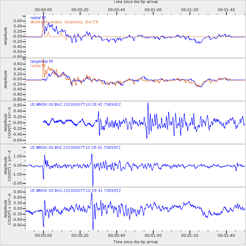
WMOK Wichita Mountains, Oklahoma, USA - Earthquake Result Viewer
*The percent match for this event was below the threshold and hence no stack was calculated.
| Earthquake location: |
Northern Peru |
| Earthquake latitude/longitude: |
-4.0/-76.9 |
| Earthquake time(UTC): |
2020/06/07 (159) 10:31:17 GMT |
| Earthquake Depth: |
99 km |
| Earthquake Magnitude: |
5.4 Mww |
| Earthquake Catalog/Contributor: |
NEIC PDE/us |
|
| Network: |
US United States National Seismic Network |
| Station: |
WMOK Wichita Mountains, Oklahoma, USA |
| Lat/Lon: |
34.74 N/98.78 W |
| Elevation: |
486 m |
|
| Distance: |
43.7 deg |
| Az: |
333.681 deg |
| Baz: |
147.518 deg |
| Ray Param: |
$rayparam |
*The percent match for this event was below the threshold and hence was not used in the summary stack. |
|
| Radial Match: |
42.59587 % |
| Radial Bump: |
400 |
| Transverse Match: |
31.925518 % |
| Transverse Bump: |
400 |
| SOD ConfigId: |
21166931 |
| Insert Time: |
2020-06-21 11:01:54.388 +0000 |
| GWidth: |
2.5 |
| Max Bumps: |
400 |
| Tol: |
0.001 |
|
Signal To Noise
| Channel | StoN | STA | LTA |
| US:WMOK:00:BHZ:20200607T10:38:42.798995Z | 7.323953 | 5.0625187E-7 | 6.912276E-8 |
| US:WMOK:00:BH1:20200607T10:38:42.798995Z | 1.9850706 | 4.7622837E-7 | 2.3990498E-7 |
| US:WMOK:00:BH2:20200607T10:38:42.798995Z | 3.199666 | 1.9069896E-7 | 5.9599643E-8 |
| Arrivals |
| Ps | |
| PpPs | |
| PsPs/PpSs | |


