You are here: Home > Network List > KN - Kyrgyz Seismic Telemetry Network Stations List
> Station TKM2 KN.TKM2 > Earthquake Result Viewer
TKM2 KN.TKM2 - Earthquake Result Viewer
| Earthquake location: |
Near East Coast Of Honshu, Japan |
| Earthquake latitude/longitude: |
36.2/141.5 |
| Earthquake time(UTC): |
2008/05/07 (128) 16:02:02 GMT |
| Earthquake Depth: |
19 km |
| Earthquake Magnitude: |
5.7 MB, 6.2 MW, 6.2 MW |
| Earthquake Catalog/Contributor: |
WHDF/NEIC |
|
| Network: |
KN Kyrgyz Seismic Telemetry Network |
| Station: |
TKM2 KN.TKM2 |
| Lat/Lon: |
42.92 N/75.60 E |
| Elevation: |
2020 m |
|
| Distance: |
50.1 deg |
| Az: |
299.078 deg |
| Baz: |
74.278 deg |
| Ray Param: |
0.068235904 |
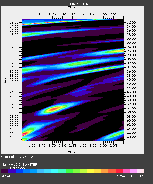
| Estimated Moho Depth: |
12.5 km |
| Estimated Crust Vp/Vs: |
1.62 |
| Assumed Crust Vp: |
6.306 km/s |
| Estimated Crust Vs: |
3.887 km/s |
| Estimated Crust Poisson's Ratio: |
0.19 |
|
| Radial Match: |
97.74712 % |
| Radial Bump: |
381 |
| Transverse Match: |
89.98013 % |
| Transverse Bump: |
400 |
| SOD ConfigId: |
2504 |
| Insert Time: |
2010-03-08 21:02:46.105 +0000 |
| GWidth: |
2.5 |
| Max Bumps: |
400 |
| Tol: |
0.001 |
|
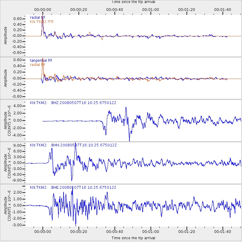
Signal To Noise
| Channel | StoN | STA | LTA |
| KN:TKM2: :BHN:20080507T16:10:25.675012Z | 56.155403 | 1.99368E-6 | 3.5502904E-8 |
| KN:TKM2: :BHE:20080507T16:10:25.675012Z | 8.459535 | 4.4699505E-7 | 5.28392E-8 |
| KN:TKM2: :BHZ:20080507T16:10:25.675012Z | 25.318316 | 9.271815E-7 | 3.662098E-8 |
| Arrivals |
| Ps | 1.3 SECOND |
| PpPs | 4.9 SECOND |
| PsPs/PpSs | 6.2 SECOND |


