TKM2 KN.TKM2 - Earthquake Result Viewer
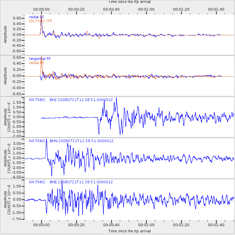
Earthquake location: Off East Coast Of Honshu, Japan
Earthquake latitude/longitude: 37.2/142.1
Earthquake time(UTC): 2008/07/21 (203) 11:30:29 GMT
Earthquake Depth: 22 km
Earthquake Magnitude: 5.7 MB, 5.6 MS, 6.0 MW, 5.9 MW
Earthquake Catalog/Contributor: WHDF/NEIC
Network: KN Kyrgyz Seismic Telemetry Network
Station: TKM2 KN.TKM2
Lat/Lon: 42.92 N/75.60 E
Elevation: 2020 m
Distance: 50.0 deg
Az: 298.477 deg
Baz: 72.873 deg
Ray Param: 0.06830901
Estimated Moho Depth: 12.75 km
Estimated Crust Vp/Vs: 1.62
Assumed Crust Vp: 6.306 km/s
Estimated Crust Vs: 3.905 km/s
Estimated Crust Poisson's Ratio: 0.19
Radial Match: 97.08613 %
Radial Bump: 336
Transverse Match: 88.427795 %
Transverse Bump: 400
SOD ConfigId: 2504
Insert Time: 2010-03-08 21:03:30.628 +0000
GWidth: 2.5
Max Bumps: 400
Tol: 0.001

Signal To Noise

ChannelStoNSTALTA
KN:TKM2: :BHN:20080721T11:38:51.000001Z32.052731.2618247E-63.936715E-8
KN:TKM2: :BHE:20080721T11:38:51.000001Z8.8995213.2273837E-73.626469E-8
KN:TKM2: :BHZ:20080721T11:38:51.000001Z13.8859025.3289466E-73.837667E-8
Arrivals
Ps1.3 SECOND
PpPs5.0 SECOND
PsPs/PpSs6.3 SECOND