You are here: Home > Network List > KN - Kyrgyz Seismic Telemetry Network Stations List
> Station TKM2 KN.TKM2 > Earthquake Result Viewer
TKM2 KN.TKM2 - Earthquake Result Viewer
| Earthquake location: |
Halmahera, Indonesia |
| Earthquake latitude/longitude: |
1.9/127.4 |
| Earthquake time(UTC): |
2008/09/11 (255) 00:00:02 GMT |
| Earthquake Depth: |
96 km |
| Earthquake Magnitude: |
6.2 MB, 6.6 MW, 6.6 MW |
| Earthquake Catalog/Contributor: |
WHDF/NEIC |
|
| Network: |
KN Kyrgyz Seismic Telemetry Network |
| Station: |
TKM2 KN.TKM2 |
| Lat/Lon: |
42.92 N/75.60 E |
| Elevation: |
2020 m |
|
| Distance: |
61.5 deg |
| Az: |
318.981 deg |
| Baz: |
116.749 deg |
| Ray Param: |
0.06055097 |
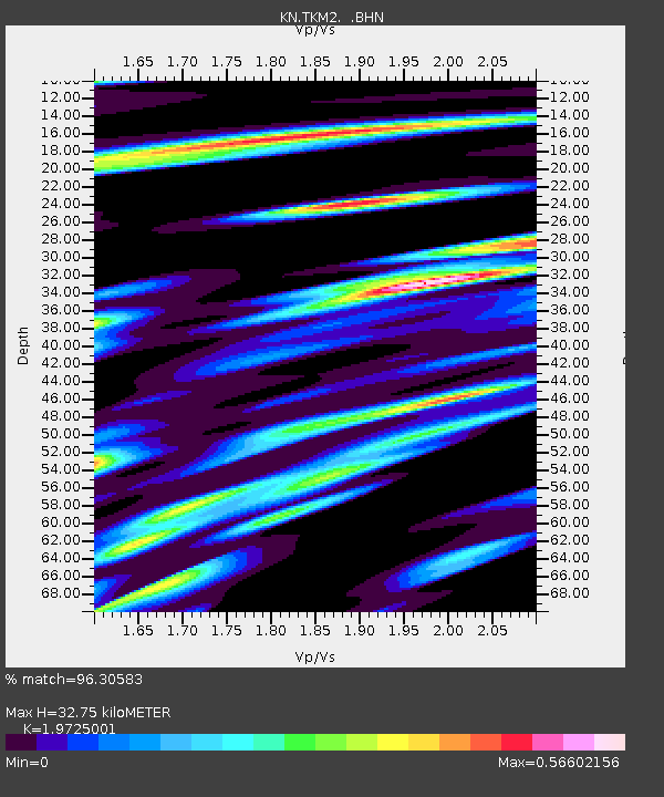
| Estimated Moho Depth: |
32.75 km |
| Estimated Crust Vp/Vs: |
1.97 |
| Assumed Crust Vp: |
6.306 km/s |
| Estimated Crust Vs: |
3.197 km/s |
| Estimated Crust Poisson's Ratio: |
0.33 |
|
| Radial Match: |
96.30583 % |
| Radial Bump: |
400 |
| Transverse Match: |
90.0392 % |
| Transverse Bump: |
400 |
| SOD ConfigId: |
2560 |
| Insert Time: |
2010-03-08 21:03:55.603 +0000 |
| GWidth: |
2.5 |
| Max Bumps: |
400 |
| Tol: |
0.001 |
|
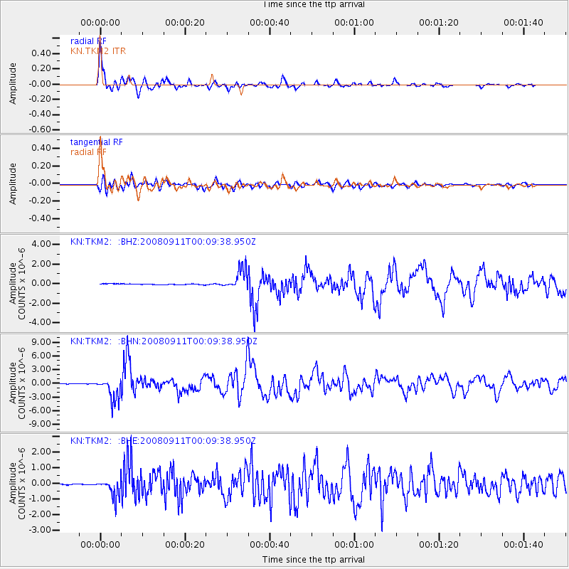
Signal To Noise
| Channel | StoN | STA | LTA |
| KN:TKM2: :BHN:20080911T00:09:38.950Z | 56.457508 | 2.562468E-6 | 4.5387548E-8 |
| KN:TKM2: :BHE:20080911T00:09:38.950Z | 23.847698 | 5.961376E-7 | 2.4997702E-8 |
| KN:TKM2: :BHZ:20080911T00:09:38.950Z | 22.655066 | 1.0913373E-6 | 4.8171884E-8 |
| Arrivals |
| Ps | 5.3 SECOND |
| PpPs | 15 SECOND |
| PsPs/PpSs | 20 SECOND |


