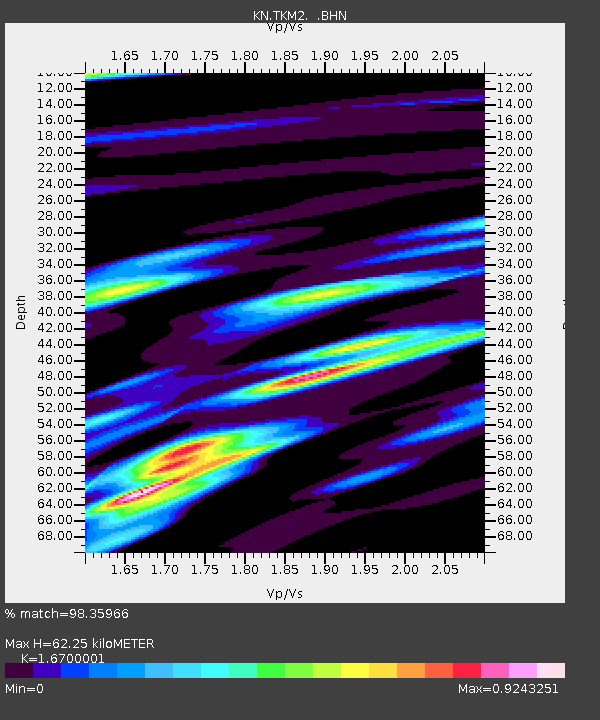
TKM2 KN.TKM2 - Earthquake Result Viewer
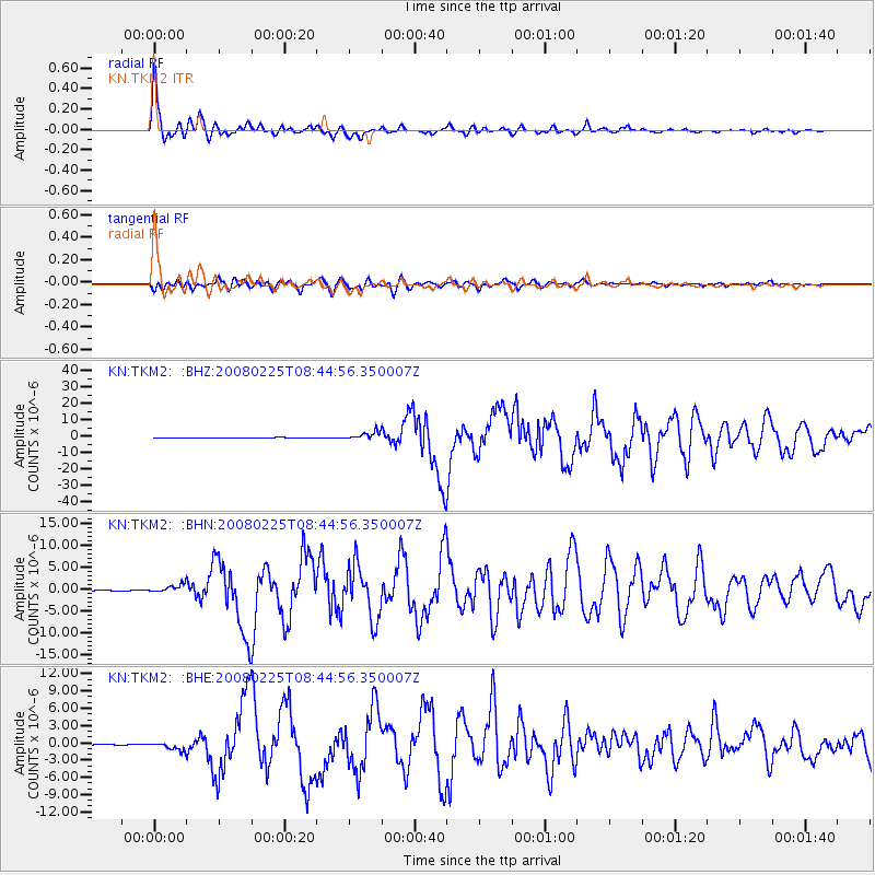
Earthquake location: Southern Sumatra, Indonesia
Earthquake latitude/longitude: -2.5/100.0
Earthquake time(UTC): 2008/02/25 (056) 08:36:33 GMT
Earthquake Depth: 25 km
Earthquake Magnitude: 6.4 MB, 7.3 MS, 7.0 MW, 6.9 MW
Earthquake Catalog/Contributor: WHDF/NEIC
Network: KN Kyrgyz Seismic Telemetry Network
Station: TKM2 KN.TKM2
Lat/Lon: 42.92 N/75.60 E
Elevation: 2020 m
Distance: 50.3 deg
Az: 336.782 deg
Baz: 147.576 deg
Ray Param: 0.06813253
Estimated Moho Depth: 62.25 km
Estimated Crust Vp/Vs: 1.67
Assumed Crust Vp: 6.306 km/s
Estimated Crust Vs: 3.776 km/s
Estimated Crust Poisson's Ratio: 0.22
Radial Match: 98.35966 %
Radial Bump: 384
Transverse Match: 95.42099 %
Transverse Bump: 400
SOD ConfigId: 2564
Insert Time: 2010-03-08 21:04:09.656 +0000
GWidth: 2.5
Max Bumps: 400
Tol: 0.001

Signal To Noise

ChannelStoNSTALTA
KN:TKM2: :BHN:20080225T08:44:56.350007Z10.7277559.366469E-78.7310625E-8
KN:TKM2: :BHE:20080225T08:44:56.350007Z12.0535437.1910796E-75.965946E-8
KN:TKM2: :BHZ:20080225T08:44:56.350007Z22.1211722.4423E-61.1040554E-7
Arrivals
Ps7.0 SECOND
PpPs25 SECOND
PsPs/PpSs32 SECOND