You are here: Home > Network List > TA - USArray Transportable Network (new EarthScope stations) Stations List
> Station M16K Timber Creek, AK, USA > Earthquake Result Viewer
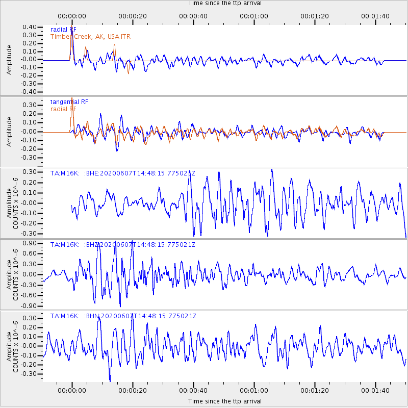
M16K Timber Creek, AK, USA - Earthquake Result Viewer

| Earthquake location: |
Santa Cruz Islands |
| Earthquake latitude/longitude: |
-10.7/166.1 |
| Earthquake time(UTC): |
2020/06/07 (159) 14:36:56 GMT |
| Earthquake Depth: |
13 km |
| Earthquake Magnitude: |
5.7 mww |
| Earthquake Catalog/Contributor: |
NEIC PDE/us |
|
| Network: |
TA USArray Transportable Network (new EarthScope stations) |
| Station: |
M16K Timber Creek, AK, USA |
| Lat/Lon: |
61.02 N/158.96 W |
| Elevation: |
394 m |
|
| Distance: |
76.6 deg |
| Az: |
16.642 deg |
| Baz: |
215.314 deg |
| Ray Param: |
0.050883602 |
| Estimated Moho Depth: |
29.75 km |
| Estimated Crust Vp/Vs: |
1.86 |
| Assumed Crust Vp: |
6.276 km/s |
| Estimated Crust Vs: |
3.37 km/s |
| Estimated Crust Poisson's Ratio: |
0.30 |
|
| Radial Match: |
82.60351 % |
| Radial Bump: |
400 |
| Transverse Match: |
71.16402 % |
| Transverse Bump: |
400 |
| SOD ConfigId: |
21166931 |
| Insert Time: |
2020-06-21 14:49:26.627 +0000 |
| GWidth: |
2.5 |
| Max Bumps: |
400 |
| Tol: |
0.001 |
|
Signal To Noise
| Channel | StoN | STA | LTA |
| TA:M16K: :BHZ:20200607T14:48:15.775021Z | 2.9157426 | 2.117469E-7 | 7.262194E-8 |
| TA:M16K: :BHN:20200607T14:48:15.775021Z | 1.4902321 | 8.676524E-8 | 5.8222636E-8 |
| TA:M16K: :BHE:20200607T14:48:15.775021Z | 0.9349166 | 6.169268E-8 | 6.598736E-8 |
| Arrivals |
| Ps | 4.2 SECOND |
| PpPs | 13 SECOND |
| PsPs/PpSs | 17 SECOND |


