You are here: Home > Network List > TA - USArray Transportable Network (new EarthScope stations) Stations List
> Station N16K Nishlik Lake, AK, USA > Earthquake Result Viewer
N16K Nishlik Lake, AK, USA - Earthquake Result Viewer
| Earthquake location: |
Santa Cruz Islands |
| Earthquake latitude/longitude: |
-10.7/166.1 |
| Earthquake time(UTC): |
2020/06/07 (159) 14:36:56 GMT |
| Earthquake Depth: |
13 km |
| Earthquake Magnitude: |
5.7 mww |
| Earthquake Catalog/Contributor: |
NEIC PDE/us |
|
| Network: |
TA USArray Transportable Network (new EarthScope stations) |
| Station: |
N16K Nishlik Lake, AK, USA |
| Lat/Lon: |
60.47 N/158.77 W |
| Elevation: |
582 m |
|
| Distance: |
76.2 deg |
| Az: |
17.049 deg |
| Baz: |
215.576 deg |
| Ray Param: |
0.051145017 |
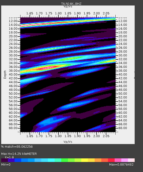
| Estimated Moho Depth: |
14.25 km |
| Estimated Crust Vp/Vs: |
1.60 |
| Assumed Crust Vp: |
6.276 km/s |
| Estimated Crust Vs: |
3.922 km/s |
| Estimated Crust Poisson's Ratio: |
0.18 |
|
| Radial Match: |
88.062256 % |
| Radial Bump: |
400 |
| Transverse Match: |
79.54449 % |
| Transverse Bump: |
400 |
| SOD ConfigId: |
21166931 |
| Insert Time: |
2020-06-21 14:49:36.492 +0000 |
| GWidth: |
2.5 |
| Max Bumps: |
400 |
| Tol: |
0.001 |
|

Signal To Noise
| Channel | StoN | STA | LTA |
| TA:N16K: :BHZ:20200607T14:48:13.549984Z | 4.91494 | 3.0799913E-7 | 6.2665904E-8 |
| TA:N16K: :BHN:20200607T14:48:13.549984Z | 1.5694757 | 1.01862675E-7 | 6.490236E-8 |
| TA:N16K: :BHE:20200607T14:48:13.549984Z | 1.7483214 | 9.477749E-8 | 5.4210567E-8 |
| Arrivals |
| Ps | 1.4 SECOND |
| PpPs | 5.7 SECOND |
| PsPs/PpSs | 7.1 SECOND |


