You are here: Home > Network List > US - United States National Seismic Network Stations List
> Station MSO Missoula, Montana, USA > Earthquake Result Viewer
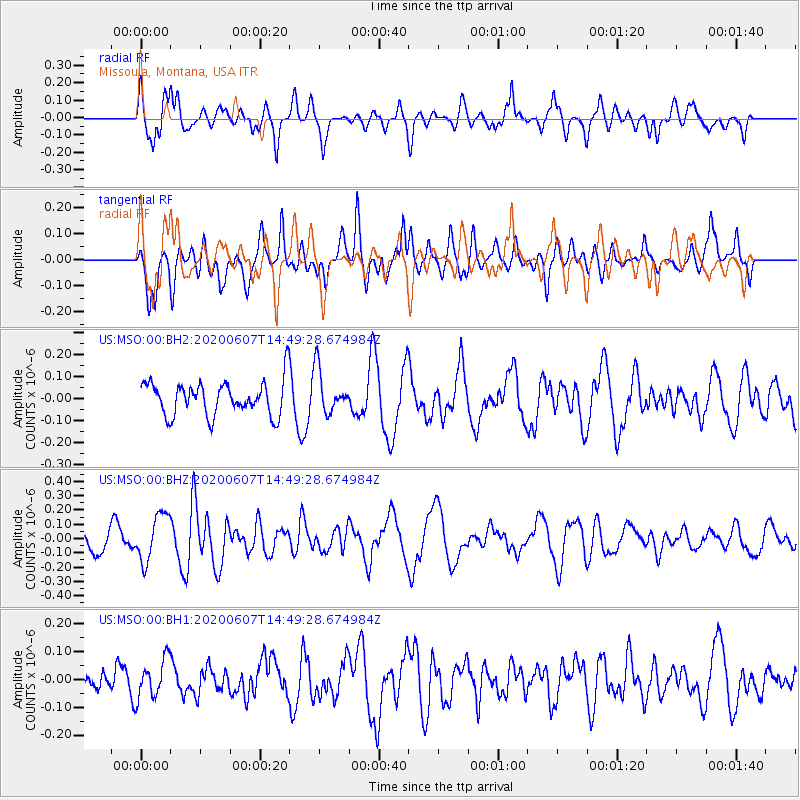
MSO Missoula, Montana, USA - Earthquake Result Viewer
*The percent match for this event was below the threshold and hence no stack was calculated.
| Earthquake location: |
Santa Cruz Islands |
| Earthquake latitude/longitude: |
-10.7/166.1 |
| Earthquake time(UTC): |
2020/06/07 (159) 14:36:56 GMT |
| Earthquake Depth: |
13 km |
| Earthquake Magnitude: |
5.7 mww |
| Earthquake Catalog/Contributor: |
NEIC PDE/us |
|
| Network: |
US United States National Seismic Network |
| Station: |
MSO Missoula, Montana, USA |
| Lat/Lon: |
46.83 N/113.94 W |
| Elevation: |
1264 m |
|
| Distance: |
90.9 deg |
| Az: |
42.539 deg |
| Baz: |
255.427 deg |
| Ray Param: |
$rayparam |
*The percent match for this event was below the threshold and hence was not used in the summary stack. |
|
| Radial Match: |
67.88314 % |
| Radial Bump: |
375 |
| Transverse Match: |
50.07899 % |
| Transverse Bump: |
400 |
| SOD ConfigId: |
21166931 |
| Insert Time: |
2020-06-21 14:51:04.560 +0000 |
| GWidth: |
2.5 |
| Max Bumps: |
400 |
| Tol: |
0.001 |
|
Signal To Noise
| Channel | StoN | STA | LTA |
| US:MSO:00:BHZ:20200607T14:49:28.674984Z | 2.1000612 | 1.6407778E-7 | 7.813E-8 |
| US:MSO:00:BH1:20200607T14:49:28.674984Z | 1.1136646 | 6.848553E-8 | 6.149564E-8 |
| US:MSO:00:BH2:20200607T14:49:28.674984Z | 1.292931 | 9.966365E-8 | 7.7083506E-8 |
| Arrivals |
| Ps | |
| PpPs | |
| PsPs/PpSs | |


