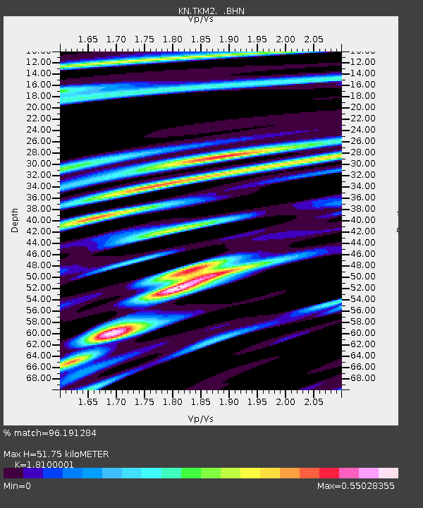
TKM2 KN.TKM2 - Earthquake Result Viewer
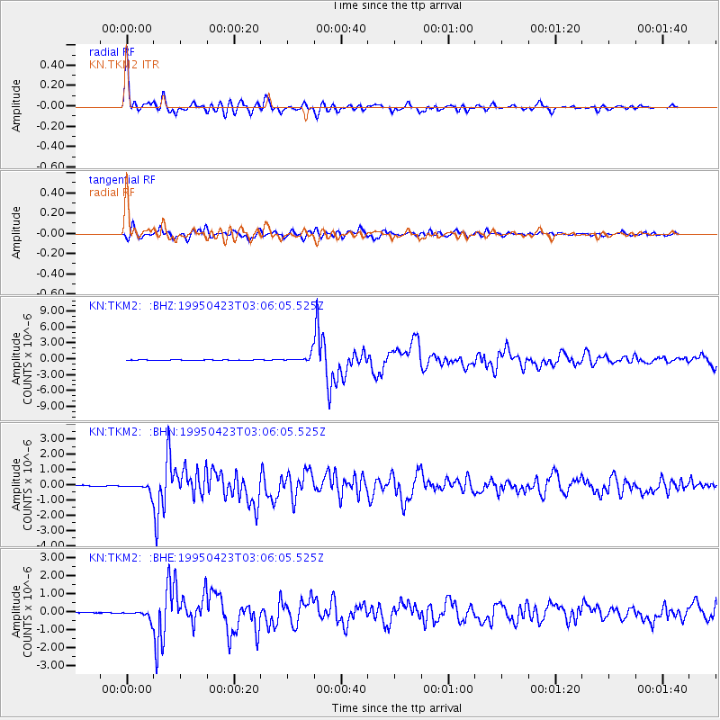
Earthquake location: Rat Islands, Aleutian Islands
Earthquake latitude/longitude: 51.3/179.7
Earthquake time(UTC): 1995/04/23 (113) 02:55:54 GMT
Earthquake Depth: 16 km
Earthquake Magnitude: 6.1 MB, 6.4 MS, 6.5 UNKNOWN, 6.7 ML
Earthquake Catalog/Contributor: WHDF/NEIC
Network: KN Kyrgyz Seismic Telemetry Network
Station: TKM2 KN.TKM2
Lat/Lon: 42.92 N/75.60 E
Elevation: 2020 m
Distance: 65.4 deg
Az: 308.425 deg
Baz: 41.987 deg
Ray Param: 0.058275428
Estimated Moho Depth: 51.75 km
Estimated Crust Vp/Vs: 1.81
Assumed Crust Vp: 6.306 km/s
Estimated Crust Vs: 3.484 km/s
Estimated Crust Poisson's Ratio: 0.28
Radial Match: 96.191284 %
Radial Bump: 400
Transverse Match: 91.47736 %
Transverse Bump: 400
SOD ConfigId: 6273
Insert Time: 2010-03-08 21:04:43.726 +0000
GWidth: 2.5
Max Bumps: 400
Tol: 0.001

Signal To Noise

ChannelStoNSTALTA
KN:TKM2: :BHN:19950423T03:06:05.525Z8.9491783.0461203E-73.4037992E-8
KN:TKM2: :BHE:19950423T03:06:05.525Z8.8773032.4644547E-72.7761299E-8
KN:TKM2: :BHZ:19950423T03:06:05.525Z23.7895367.897747E-73.3198408E-8
Arrivals
Ps6.9 SECOND
PpPs22 SECOND
PsPs/PpSs29 SECOND