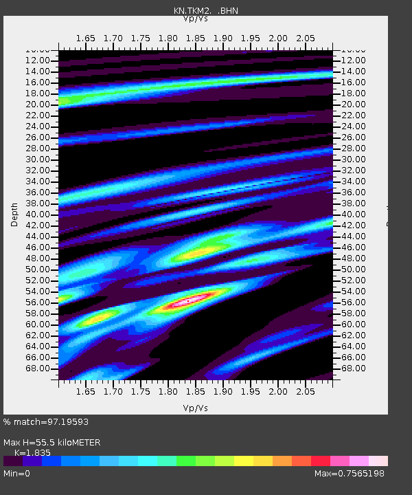
TKM2 KN.TKM2 - Earthquake Result Viewer
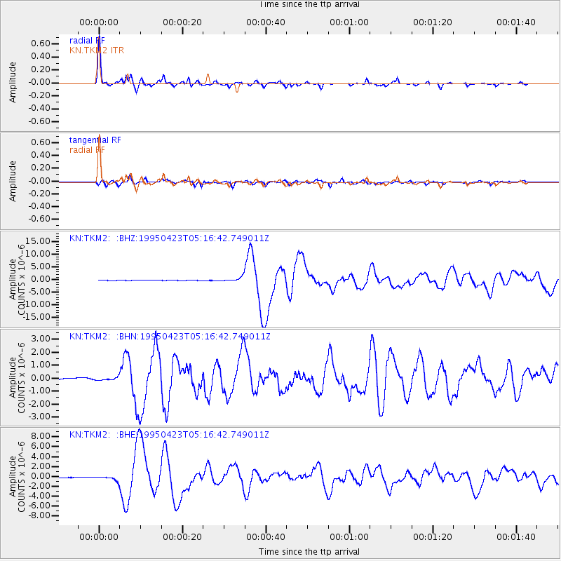
Earthquake location: Samar, Philippines
Earthquake latitude/longitude: 12.4/125.4
Earthquake time(UTC): 1995/04/23 (113) 05:08:03 GMT
Earthquake Depth: 33 km
Earthquake Magnitude: 6.0 MB, 6.6 MS, 6.7 UNKNOWN, 6.7 MW
Earthquake Catalog/Contributor: WHDF/NEIC
Network: KN Kyrgyz Seismic Telemetry Network
Station: TKM2 KN.TKM2
Lat/Lon: 42.92 N/75.60 E
Elevation: 2020 m
Distance: 52.5 deg
Az: 315.057 deg
Baz: 110.018 deg
Ray Param: 0.066627756
Estimated Moho Depth: 55.5 km
Estimated Crust Vp/Vs: 1.84
Assumed Crust Vp: 6.306 km/s
Estimated Crust Vs: 3.437 km/s
Estimated Crust Poisson's Ratio: 0.29
Radial Match: 97.19593 %
Radial Bump: 319
Transverse Match: 90.588875 %
Transverse Bump: 400
SOD ConfigId: 6273
Insert Time: 2010-03-08 21:05:01.209 +0000
GWidth: 2.5
Max Bumps: 400
Tol: 0.001

Signal To Noise

ChannelStoNSTALTA
KN:TKM2: :BHN:19950423T05:16:42.749011Z1.69459621.07925196E-76.368786E-8
KN:TKM2: :BHE:19950423T05:16:42.749011Z4.37290764.58984E-71.04960826E-7
KN:TKM2: :BHZ:19950423T05:16:42.749011Z13.1908859.653043E-77.317965E-8
Arrivals
Ps7.7 SECOND
PpPs24 SECOND
PsPs/PpSs31 SECOND