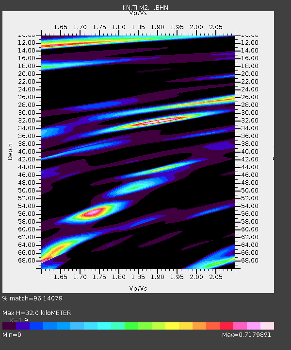
TKM2 KN.TKM2 - Earthquake Result Viewer
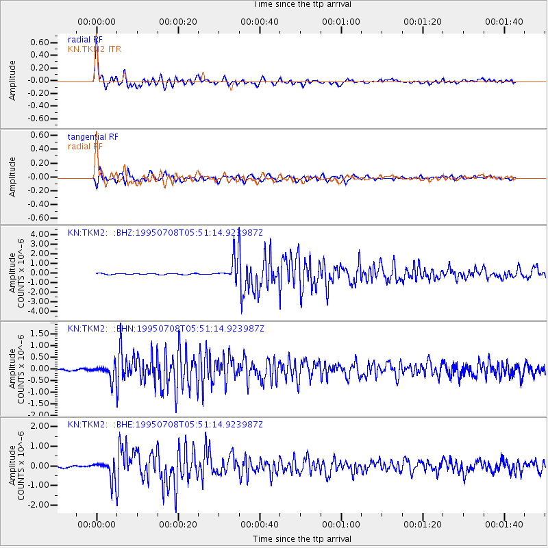
Earthquake location: Off East Coast Of Honshu, Japan
Earthquake latitude/longitude: 39.6/143.4
Earthquake time(UTC): 1995/07/08 (189) 05:42:56 GMT
Earthquake Depth: 40 km
Earthquake Magnitude: 5.7 MB, 5.5 MS, 5.2 UNKNOWN, 6.0 MW
Earthquake Catalog/Contributor: WHDF/NEIC
Network: KN Kyrgyz Seismic Telemetry Network
Station: TKM2 KN.TKM2
Lat/Lon: 42.92 N/75.60 E
Elevation: 2020 m
Distance: 49.8 deg
Az: 297.055 deg
Baz: 69.415 deg
Ray Param: 0.06840286
Estimated Moho Depth: 32.0 km
Estimated Crust Vp/Vs: 1.90
Assumed Crust Vp: 6.306 km/s
Estimated Crust Vs: 3.319 km/s
Estimated Crust Poisson's Ratio: 0.31
Radial Match: 96.14079 %
Radial Bump: 400
Transverse Match: 91.214035 %
Transverse Bump: 400
SOD ConfigId: 6273
Insert Time: 2010-03-08 21:05:20.657 +0000
GWidth: 2.5
Max Bumps: 400
Tol: 0.001

Signal To Noise

ChannelStoNSTALTA
KN:TKM2: :BHN:19950708T05:51:14.923987Z10.55882553.131359E-72.965632E-8
KN:TKM2: :BHE:19950708T05:51:14.923987Z13.0640735.3464214E-74.0924615E-8
KN:TKM2: :BHZ:19950708T05:51:14.923987Z23.5152281.2334343E-65.2452574E-8
Arrivals
Ps4.8 SECOND
PpPs14 SECOND
PsPs/PpSs19 SECOND