You are here: Home > Network List > TA - USArray Transportable Network (new EarthScope stations) Stations List
> Station F21K Alatna River, AK, USA > Earthquake Result Viewer
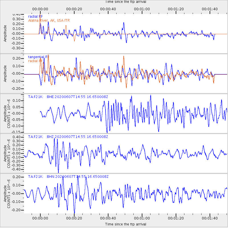
F21K Alatna River, AK, USA - Earthquake Result Viewer
*The percent match for this event was below the threshold and hence no stack was calculated.
| Earthquake location: |
Santa Cruz Islands |
| Earthquake latitude/longitude: |
-10.7/166.1 |
| Earthquake time(UTC): |
2020/06/07 (159) 14:43:24 GMT |
| Earthquake Depth: |
22 km |
| Earthquake Magnitude: |
5.7 Mww |
| Earthquake Catalog/Contributor: |
NEIC PDE/us |
|
| Network: |
TA USArray Transportable Network (new EarthScope stations) |
| Station: |
F21K Alatna River, AK, USA |
| Lat/Lon: |
67.22 N/153.48 W |
| Elevation: |
597 m |
|
| Distance: |
83.0 deg |
| Az: |
14.729 deg |
| Baz: |
219.929 deg |
| Ray Param: |
$rayparam |
*The percent match for this event was below the threshold and hence was not used in the summary stack. |
|
| Radial Match: |
67.17444 % |
| Radial Bump: |
400 |
| Transverse Match: |
70.67374 % |
| Transverse Bump: |
400 |
| SOD ConfigId: |
21166931 |
| Insert Time: |
2020-06-21 15:01:57.314 +0000 |
| GWidth: |
2.5 |
| Max Bumps: |
400 |
| Tol: |
0.001 |
|
Signal To Noise
| Channel | StoN | STA | LTA |
| TA:F21K: :BHZ:20200607T14:55:16.650008Z | 2.3153238 | 1.3196023E-7 | 5.699429E-8 |
| TA:F21K: :BHN:20200607T14:55:16.650008Z | 1.2656343 | 4.7528456E-8 | 3.755307E-8 |
| TA:F21K: :BHE:20200607T14:55:16.650008Z | 0.7266721 | 2.1775834E-8 | 2.9966518E-8 |
| Arrivals |
| Ps | |
| PpPs | |
| PsPs/PpSs | |


