You are here: Home > Network List > AK - Alaska Regional Network Stations List
> Station J20K Nowitna River, AK, USA > Earthquake Result Viewer
J20K Nowitna River, AK, USA - Earthquake Result Viewer
| Earthquake location: |
New Britain Region, P.N.G. |
| Earthquake latitude/longitude: |
-5.4/151.7 |
| Earthquake time(UTC): |
2020/06/07 (159) 20:06:38 GMT |
| Earthquake Depth: |
53 km |
| Earthquake Magnitude: |
5.9 mww |
| Earthquake Catalog/Contributor: |
NEIC PDE/us |
|
| Network: |
AK Alaska Regional Network |
| Station: |
J20K Nowitna River, AK, USA |
| Lat/Lon: |
64.18 N/154.15 W |
| Elevation: |
314 m |
|
| Distance: |
80.1 deg |
| Az: |
21.133 deg |
| Baz: |
235.047 deg |
| Ray Param: |
0.04840722 |
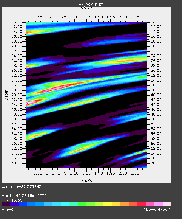
| Estimated Moho Depth: |
43.25 km |
| Estimated Crust Vp/Vs: |
1.61 |
| Assumed Crust Vp: |
6.566 km/s |
| Estimated Crust Vs: |
4.091 km/s |
| Estimated Crust Poisson's Ratio: |
0.18 |
|
| Radial Match: |
87.575745 % |
| Radial Bump: |
349 |
| Transverse Match: |
67.81342 % |
| Transverse Bump: |
376 |
| SOD ConfigId: |
21166931 |
| Insert Time: |
2020-06-21 20:08:23.082 +0000 |
| GWidth: |
2.5 |
| Max Bumps: |
400 |
| Tol: |
0.001 |
|

Signal To Noise
| Channel | StoN | STA | LTA |
| AK:J20K: :BHZ:20200607T20:18:12.279973Z | 11.320249 | 4.963728E-7 | 4.3848228E-8 |
| AK:J20K: :BHN:20200607T20:18:12.279973Z | 5.5060167 | 1.3251872E-7 | 2.4067985E-8 |
| AK:J20K: :BHE:20200607T20:18:12.279973Z | 5.842656 | 1.8107855E-7 | 3.0992503E-8 |
| Arrivals |
| Ps | 4.1 SECOND |
| PpPs | 17 SECOND |
| PsPs/PpSs | 21 SECOND |


