You are here: Home > Network List > KN - Kyrgyz Seismic Telemetry Network Stations List
> Station TKM2 KN.TKM2 > Earthquake Result Viewer
TKM2 KN.TKM2 - Earthquake Result Viewer
| Earthquake location: |
Banda Sea |
| Earthquake latitude/longitude: |
-6.9/129.2 |
| Earthquake time(UTC): |
1995/12/25 (359) 04:43:24 GMT |
| Earthquake Depth: |
150 km |
| Earthquake Magnitude: |
6.2 MB, 7.1 UNKNOWN, 7.1 MW |
| Earthquake Catalog/Contributor: |
WHDF/NEIC |
|
| Network: |
KN Kyrgyz Seismic Telemetry Network |
| Station: |
TKM2 KN.TKM2 |
| Lat/Lon: |
42.92 N/75.60 E |
| Elevation: |
2020 m |
|
| Distance: |
69.4 deg |
| Az: |
320.847 deg |
| Baz: |
121.425 deg |
| Ray Param: |
0.05524816 |
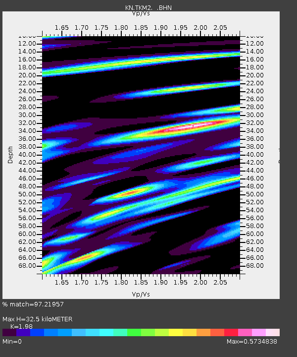
| Estimated Moho Depth: |
32.5 km |
| Estimated Crust Vp/Vs: |
1.98 |
| Assumed Crust Vp: |
6.306 km/s |
| Estimated Crust Vs: |
3.185 km/s |
| Estimated Crust Poisson's Ratio: |
0.33 |
|
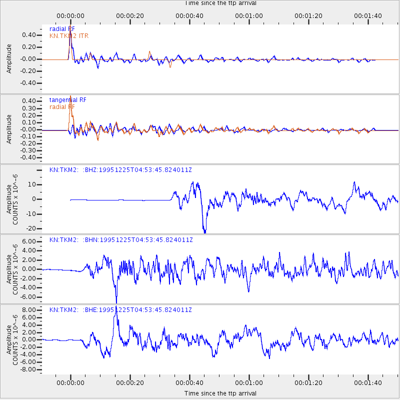
| Radial Match: |
97.21957 % |
| Radial Bump: |
400 |
| Transverse Match: |
87.2294 % |
| Transverse Bump: |
400 |
| SOD ConfigId: |
6273 |
| Insert Time: |
2010-03-08 21:05:49.624 +0000 |
| GWidth: |
2.5 |
| Max Bumps: |
400 |
| Tol: |
0.001 |
|
Signal To Noise
| Channel | StoN | STA | LTA |
| KN:TKM2: :BHN:19951225T04:53:45.824011Z | 2.696143 | 2.1778091E-7 | 8.077499E-8 |
| KN:TKM2: :BHE:19951225T04:53:45.824011Z | 3.491649 | 3.952475E-7 | 1.1319795E-7 |
| KN:TKM2: :BHZ:19951225T04:53:45.824011Z | 11.142505 | 1.3584273E-6 | 1.21914E-7 |
| Arrivals |
| Ps | 5.2 SECOND |
| PpPs | 15 SECOND |
| PsPs/PpSs | 20 SECOND |


