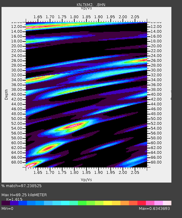
TKM2 KN.TKM2 - Earthquake Result Viewer

Earthquake location: Near East Coast Of Honshu, Japan
Earthquake latitude/longitude: 35.5/140.9
Earthquake time(UTC): 1996/09/11 (255) 02:37:14 GMT
Earthquake Depth: 55 km
Earthquake Magnitude: 6.1 MB, 5.7 MS, 6.2 UNKNOWN, 6.1 MW
Earthquake Catalog/Contributor: WHDF/NEIC
Network: KN Kyrgyz Seismic Telemetry Network
Station: TKM2 KN.TKM2
Lat/Lon: 42.92 N/75.60 E
Elevation: 2020 m
Distance: 50.0 deg
Az: 299.394 deg
Baz: 75.318 deg
Ray Param: 0.06818633
Estimated Moho Depth: 69.25 km
Estimated Crust Vp/Vs: 1.62
Assumed Crust Vp: 6.306 km/s
Estimated Crust Vs: 3.905 km/s
Estimated Crust Poisson's Ratio: 0.19
Radial Match: 97.238525 %
Radial Bump: 383
Transverse Match: 95.09898 %
Transverse Bump: 400
SOD ConfigId: 6273
Insert Time: 2010-03-08 21:06:03.328 +0000
GWidth: 2.5
Max Bumps: 400
Tol: 0.001

Signal To Noise

ChannelStoNSTALTA
KN:TKM2: :BHN:19960911T02:45:33.275Z1.66193288.75558E-85.2683113E-8
KN:TKM2: :BHE:19960911T02:45:33.275Z3.89272792.0975915E-75.3884875E-8
KN:TKM2: :BHZ:19960911T02:45:33.275Z7.84709365.818468E-77.414807E-8
Arrivals
Ps7.2 SECOND
PpPs27 SECOND
PsPs/PpSs34 SECOND