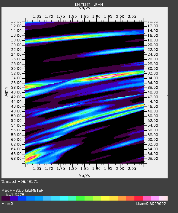
TKM2 KN.TKM2 - Earthquake Result Viewer
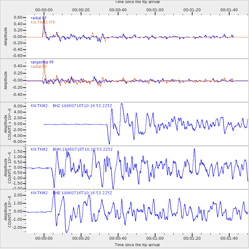
Earthquake location: Minahassa Peninsula, Sulawesi
Earthquake latitude/longitude: 1.0/120.3
Earthquake time(UTC): 1996/07/16 (198) 10:07:36 GMT
Earthquake Depth: 33 km
Earthquake Magnitude: 6.0 MB, 6.4 MS, 6.6 UNKNOWN, 6.6 MW
Earthquake Catalog/Contributor: WHDF/NEIC
Network: KN Kyrgyz Seismic Telemetry Network
Station: TKM2 KN.TKM2
Lat/Lon: 42.92 N/75.60 E
Elevation: 2020 m
Distance: 57.7 deg
Az: 322.35 deg
Baz: 123.754 deg
Ray Param: 0.06326872
Estimated Moho Depth: 33.0 km
Estimated Crust Vp/Vs: 1.95
Assumed Crust Vp: 6.306 km/s
Estimated Crust Vs: 3.238 km/s
Estimated Crust Poisson's Ratio: 0.32
Radial Match: 96.48171 %
Radial Bump: 385
Transverse Match: 90.39002 %
Transverse Bump: 400
SOD ConfigId: 6273
Insert Time: 2010-03-08 21:06:41.196 +0000
GWidth: 2.5
Max Bumps: 400
Tol: 0.001

Signal To Noise

ChannelStoNSTALTA
KN:TKM2: :BHN:19960716T10:16:53.225Z6.8716551.9485843E-72.835684E-8
KN:TKM2: :BHE:19960716T10:16:53.225Z15.5175634.0254295E-72.594112E-8
KN:TKM2: :BHZ:19960716T10:16:53.225Z21.2418421.2209376E-65.7477955E-8
Arrivals
Ps5.2 SECOND
PpPs15 SECOND
PsPs/PpSs20 SECOND