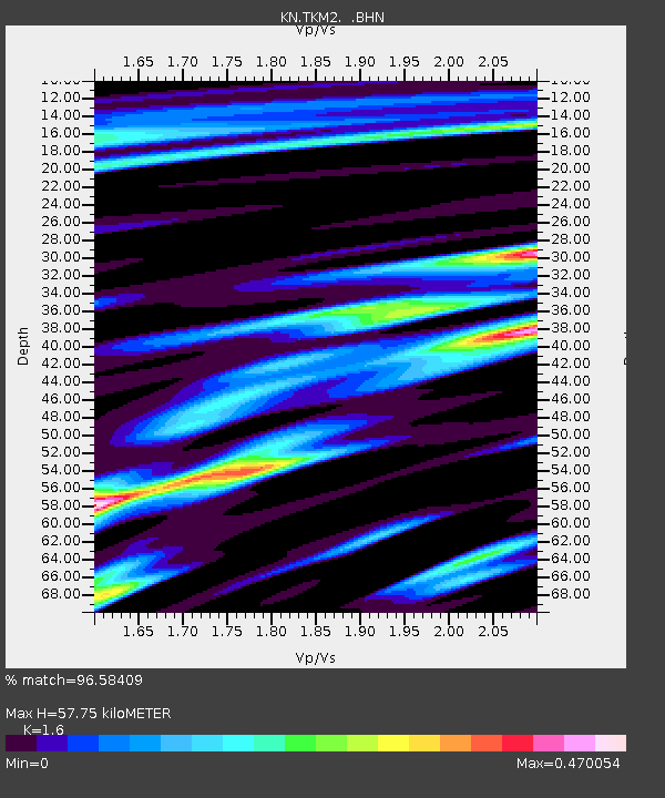
TKM2 KN.TKM2 - Earthquake Result Viewer
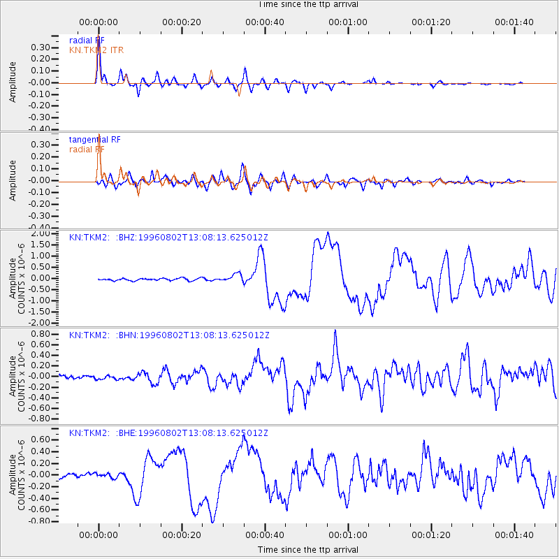
Earthquake location: Solomon Islands
Earthquake latitude/longitude: -10.8/161.4
Earthquake time(UTC): 1996/08/02 (215) 12:55:29 GMT
Earthquake Depth: 33 km
Earthquake Magnitude: 6.2 MB, 7.1 MS, 6.9 UNKNOWN, 6.9 MW
Earthquake Catalog/Contributor: WHDF/NEIC
Network: KN Kyrgyz Seismic Telemetry Network
Station: TKM2 KN.TKM2
Lat/Lon: 42.92 N/75.60 E
Elevation: 2020 m
Distance: 94.2 deg
Az: 312.723 deg
Baz: 100.669 deg
Ray Param: 0.041080054
Estimated Moho Depth: 57.75 km
Estimated Crust Vp/Vs: 1.60
Assumed Crust Vp: 6.306 km/s
Estimated Crust Vs: 3.941 km/s
Estimated Crust Poisson's Ratio: 0.18
Radial Match: 96.58409 %
Radial Bump: 340
Transverse Match: 89.25638 %
Transverse Bump: 400
SOD ConfigId: 6273
Insert Time: 2010-03-08 21:06:44.673 +0000
GWidth: 2.5
Max Bumps: 400
Tol: 0.001

Signal To Noise

ChannelStoNSTALTA
KN:TKM2: :BHN:19960802T13:08:13.625012Z0.81369553.3751114E-84.1478803E-8
KN:TKM2: :BHE:19960802T13:08:13.625012Z1.17110153.8086842E-83.2522237E-8
KN:TKM2: :BHZ:19960802T13:08:13.625012Z3.59421941.8362928E-75.109017E-8
Arrivals
Ps5.6 SECOND
PpPs23 SECOND
PsPs/PpSs29 SECOND