You are here: Home > Network List > IN - National Seismic Network of India Stations List
> Station SHL Shillong, Meghalaya, India > Earthquake Result Viewer
SHL Shillong, Meghalaya, India - Earthquake Result Viewer
| Earthquake location: |
New Britain Region, P.N.G. |
| Earthquake latitude/longitude: |
-5.4/151.7 |
| Earthquake time(UTC): |
2020/06/07 (159) 20:06:38 GMT |
| Earthquake Depth: |
53 km |
| Earthquake Magnitude: |
5.9 mww |
| Earthquake Catalog/Contributor: |
NEIC PDE/us |
|
| Network: |
IN National Seismic Network of India |
| Station: |
SHL Shillong, Meghalaya, India |
| Lat/Lon: |
25.57 N/91.86 E |
| Elevation: |
2.0 m |
|
| Distance: |
65.6 deg |
| Az: |
301.024 deg |
| Baz: |
109.146 deg |
| Ray Param: |
0.058017258 |
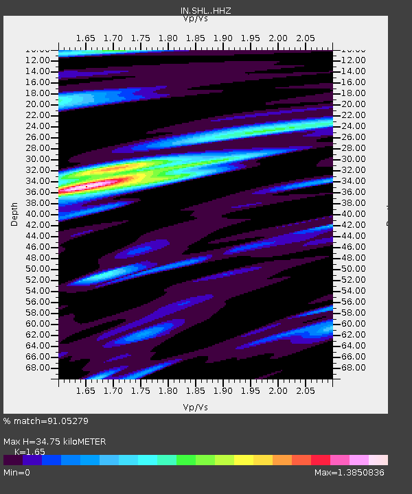
| Estimated Moho Depth: |
34.75 km |
| Estimated Crust Vp/Vs: |
1.65 |
| Assumed Crust Vp: |
6.273 km/s |
| Estimated Crust Vs: |
3.802 km/s |
| Estimated Crust Poisson's Ratio: |
0.21 |
|
| Radial Match: |
91.05279 % |
| Radial Bump: |
363 |
| Transverse Match: |
73.25998 % |
| Transverse Bump: |
400 |
| SOD ConfigId: |
21166931 |
| Insert Time: |
2020-06-21 20:16:51.773 +0000 |
| GWidth: |
2.5 |
| Max Bumps: |
400 |
| Tol: |
0.001 |
|

Signal To Noise
| Channel | StoN | STA | LTA |
| IN:SHL: :HHZ:20200607T20:16:46.88001Z | 11.431618 | 8.444685E-7 | 7.3871306E-8 |
| IN:SHL: :HHN:20200607T20:16:46.88001Z | 2.1690972 | 1.4492097E-7 | 6.681166E-8 |
| IN:SHL: :HHE:20200607T20:16:46.88001Z | 11.325361 | 5.0748235E-7 | 4.4809372E-8 |
| Arrivals |
| Ps | 3.8 SECOND |
| PpPs | 14 SECOND |
| PsPs/PpSs | 18 SECOND |


