You are here: Home > Network List > TA - USArray Transportable Network (new EarthScope stations) Stations List
> Station C16K Lisburne Hills, AK, USA > Earthquake Result Viewer
C16K Lisburne Hills, AK, USA - Earthquake Result Viewer
| Earthquake location: |
New Britain Region, P.N.G. |
| Earthquake latitude/longitude: |
-5.4/151.7 |
| Earthquake time(UTC): |
2020/06/07 (159) 20:06:38 GMT |
| Earthquake Depth: |
53 km |
| Earthquake Magnitude: |
5.9 mww |
| Earthquake Catalog/Contributor: |
NEIC PDE/us |
|
| Network: |
TA USArray Transportable Network (new EarthScope stations) |
| Station: |
C16K Lisburne Hills, AK, USA |
| Lat/Lon: |
68.27 N/165.34 W |
| Elevation: |
102 m |
|
| Distance: |
79.3 deg |
| Az: |
14.971 deg |
| Baz: |
223.7 deg |
| Ray Param: |
0.048935078 |
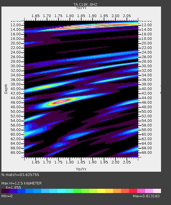
| Estimated Moho Depth: |
12.5 km |
| Estimated Crust Vp/Vs: |
1.86 |
| Assumed Crust Vp: |
5.906 km/s |
| Estimated Crust Vs: |
3.184 km/s |
| Estimated Crust Poisson's Ratio: |
0.30 |
|
| Radial Match: |
83.625755 % |
| Radial Bump: |
400 |
| Transverse Match: |
75.38941 % |
| Transverse Bump: |
400 |
| SOD ConfigId: |
21166931 |
| Insert Time: |
2020-06-21 20:20:15.960 +0000 |
| GWidth: |
2.5 |
| Max Bumps: |
400 |
| Tol: |
0.001 |
|
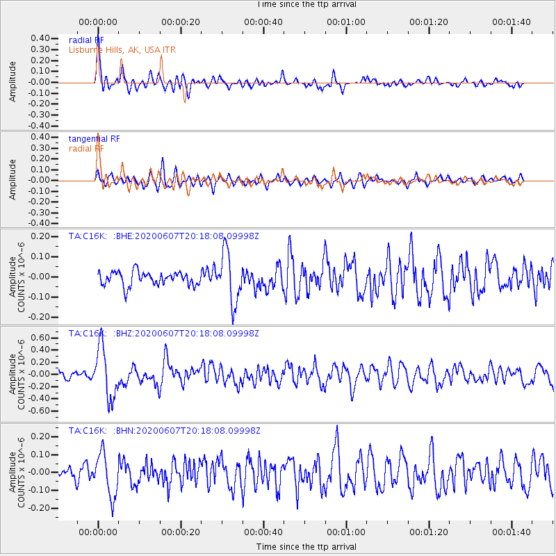
Signal To Noise
| Channel | StoN | STA | LTA |
| TA:C16K: :BHZ:20200607T20:18:08.09998Z | 8.125706 | 4.3292812E-7 | 5.3278836E-8 |
| TA:C16K: :BHN:20200607T20:18:08.09998Z | 3.873987 | 1.2285753E-7 | 3.171346E-8 |
| TA:C16K: :BHE:20200607T20:18:08.09998Z | 3.796239 | 1.2997573E-7 | 3.4238028E-8 |
| Arrivals |
| Ps | 1.9 SECOND |
| PpPs | 5.9 SECOND |
| PsPs/PpSs | 7.8 SECOND |


