You are here: Home > Network List > TA - USArray Transportable Network (new EarthScope stations) Stations List
> Station E20K Nigu River, AK, USA > Earthquake Result Viewer
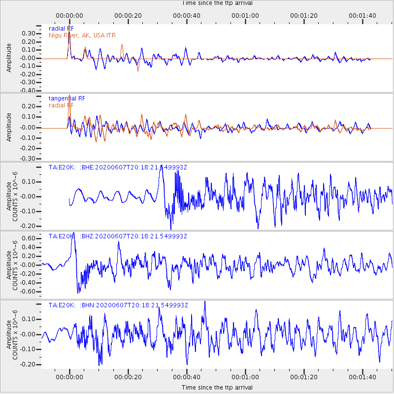
E20K Nigu River, AK, USA - Earthquake Result Viewer
*The percent match for this event was below the threshold and hence no stack was calculated.
| Earthquake location: |
New Britain Region, P.N.G. |
| Earthquake latitude/longitude: |
-5.4/151.7 |
| Earthquake time(UTC): |
2020/06/07 (159) 20:06:38 GMT |
| Earthquake Depth: |
53 km |
| Earthquake Magnitude: |
5.9 mww |
| Earthquake Catalog/Contributor: |
NEIC PDE/us |
|
| Network: |
TA USArray Transportable Network (new EarthScope stations) |
| Station: |
E20K Nigu River, AK, USA |
| Lat/Lon: |
68.26 N/156.19 W |
| Elevation: |
866 m |
|
| Distance: |
81.9 deg |
| Az: |
17.288 deg |
| Baz: |
232.577 deg |
| Ray Param: |
$rayparam |
*The percent match for this event was below the threshold and hence was not used in the summary stack. |
|
| Radial Match: |
79.570854 % |
| Radial Bump: |
400 |
| Transverse Match: |
76.40491 % |
| Transverse Bump: |
400 |
| SOD ConfigId: |
21166931 |
| Insert Time: |
2020-06-21 20:20:41.062 +0000 |
| GWidth: |
2.5 |
| Max Bumps: |
400 |
| Tol: |
0.001 |
|
Signal To Noise
| Channel | StoN | STA | LTA |
| TA:E20K: :BHZ:20200607T20:18:21.549993Z | 8.397846 | 4.3589307E-7 | 5.1905342E-8 |
| TA:E20K: :BHN:20200607T20:18:21.549993Z | 1.2028499 | 4.229433E-8 | 3.5161772E-8 |
| TA:E20K: :BHE:20200607T20:18:21.549993Z | 4.432557 | 1.2226864E-7 | 2.7584226E-8 |
| Arrivals |
| Ps | |
| PpPs | |
| PsPs/PpSs | |


