You are here: Home > Network List > TA - USArray Transportable Network (new EarthScope stations) Stations List
> Station G31M Satah River, YT, CAN > Earthquake Result Viewer
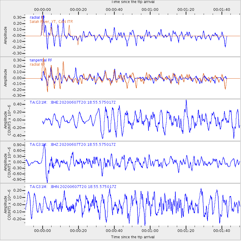
G31M Satah River, YT, CAN - Earthquake Result Viewer
*The percent match for this event was below the threshold and hence no stack was calculated.
| Earthquake location: |
New Britain Region, P.N.G. |
| Earthquake latitude/longitude: |
-5.4/151.7 |
| Earthquake time(UTC): |
2020/06/07 (159) 20:06:38 GMT |
| Earthquake Depth: |
53 km |
| Earthquake Magnitude: |
5.9 mww |
| Earthquake Catalog/Contributor: |
NEIC PDE/us |
|
| Network: |
TA USArray Transportable Network (new EarthScope stations) |
| Station: |
G31M Satah River, YT, CAN |
| Lat/Lon: |
66.92 N/134.27 W |
| Elevation: |
61 m |
|
| Distance: |
88.7 deg |
| Az: |
22.281 deg |
| Baz: |
253.268 deg |
| Ray Param: |
$rayparam |
*The percent match for this event was below the threshold and hence was not used in the summary stack. |
|
| Radial Match: |
78.64977 % |
| Radial Bump: |
360 |
| Transverse Match: |
53.98492 % |
| Transverse Bump: |
382 |
| SOD ConfigId: |
21166931 |
| Insert Time: |
2020-06-21 20:21:31.318 +0000 |
| GWidth: |
2.5 |
| Max Bumps: |
400 |
| Tol: |
0.001 |
|
Signal To Noise
| Channel | StoN | STA | LTA |
| TA:G31M: :BHZ:20200607T20:18:55.575017Z | 7.0033517 | 5.6144E-7 | 8.016733E-8 |
| TA:G31M: :BHN:20200607T20:18:55.575017Z | 0.58642185 | 6.715927E-8 | 1.1452382E-7 |
| TA:G31M: :BHE:20200607T20:18:55.575017Z | 2.882827 | 2.509601E-7 | 8.705347E-8 |
| Arrivals |
| Ps | |
| PpPs | |
| PsPs/PpSs | |


