You are here: Home > Network List > TA - USArray Transportable Network (new EarthScope stations) Stations List
> Station L15K Ungalak Mountain, AK, USA > Earthquake Result Viewer
L15K Ungalak Mountain, AK, USA - Earthquake Result Viewer
| Earthquake location: |
New Britain Region, P.N.G. |
| Earthquake latitude/longitude: |
-5.4/151.7 |
| Earthquake time(UTC): |
2020/06/07 (159) 20:06:38 GMT |
| Earthquake Depth: |
53 km |
| Earthquake Magnitude: |
5.9 mww |
| Earthquake Catalog/Contributor: |
NEIC PDE/us |
|
| Network: |
TA USArray Transportable Network (new EarthScope stations) |
| Station: |
L15K Ungalak Mountain, AK, USA |
| Lat/Lon: |
61.68 N/161.49 W |
| Elevation: |
219 m |
|
| Distance: |
75.9 deg |
| Az: |
21.02 deg |
| Baz: |
228.493 deg |
| Ray Param: |
0.05123897 |
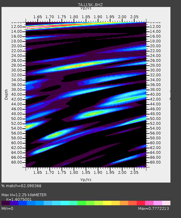
| Estimated Moho Depth: |
12.25 km |
| Estimated Crust Vp/Vs: |
1.61 |
| Assumed Crust Vp: |
6.182 km/s |
| Estimated Crust Vs: |
3.846 km/s |
| Estimated Crust Poisson's Ratio: |
0.18 |
|
| Radial Match: |
82.098366 % |
| Radial Bump: |
400 |
| Transverse Match: |
74.60182 % |
| Transverse Bump: |
400 |
| SOD ConfigId: |
21166931 |
| Insert Time: |
2020-06-21 20:22:02.387 +0000 |
| GWidth: |
2.5 |
| Max Bumps: |
400 |
| Tol: |
0.001 |
|

Signal To Noise
| Channel | StoN | STA | LTA |
| TA:L15K: :BHZ:20200607T20:17:49.150029Z | 9.682142 | 4.33107E-7 | 4.473256E-8 |
| TA:L15K: :BHN:20200607T20:17:49.150029Z | 3.2984362 | 1.418844E-7 | 4.3015653E-8 |
| TA:L15K: :BHE:20200607T20:17:49.150029Z | 2.0123954 | 9.641615E-8 | 4.791114E-8 |
| Arrivals |
| Ps | 1.2 SECOND |
| PpPs | 5.0 SECOND |
| PsPs/PpSs | 6.2 SECOND |


