You are here: Home > Network List > TA - USArray Transportable Network (new EarthScope stations) Stations List
> Station L16K Owhat River, AK, USA > Earthquake Result Viewer
L16K Owhat River, AK, USA - Earthquake Result Viewer
| Earthquake location: |
New Britain Region, P.N.G. |
| Earthquake latitude/longitude: |
-5.4/151.7 |
| Earthquake time(UTC): |
2020/06/07 (159) 20:06:38 GMT |
| Earthquake Depth: |
53 km |
| Earthquake Magnitude: |
5.9 mww |
| Earthquake Catalog/Contributor: |
NEIC PDE/us |
|
| Network: |
TA USArray Transportable Network (new EarthScope stations) |
| Station: |
L16K Owhat River, AK, USA |
| Lat/Lon: |
61.71 N/159.47 W |
| Elevation: |
227 m |
|
| Distance: |
76.7 deg |
| Az: |
21.636 deg |
| Baz: |
230.408 deg |
| Ray Param: |
0.05073711 |
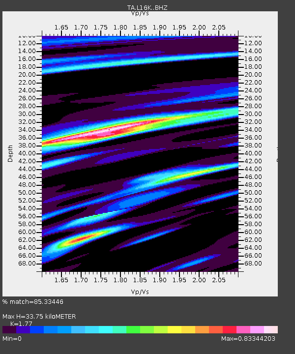
| Estimated Moho Depth: |
33.75 km |
| Estimated Crust Vp/Vs: |
1.77 |
| Assumed Crust Vp: |
6.276 km/s |
| Estimated Crust Vs: |
3.546 km/s |
| Estimated Crust Poisson's Ratio: |
0.27 |
|
| Radial Match: |
85.33446 % |
| Radial Bump: |
375 |
| Transverse Match: |
56.649418 % |
| Transverse Bump: |
400 |
| SOD ConfigId: |
21166931 |
| Insert Time: |
2020-06-21 20:22:05.147 +0000 |
| GWidth: |
2.5 |
| Max Bumps: |
400 |
| Tol: |
0.001 |
|

Signal To Noise
| Channel | StoN | STA | LTA |
| TA:L16K: :BHZ:20200607T20:17:53.400029Z | 10.559607 | 4.2278836E-7 | 4.0038266E-8 |
| TA:L16K: :BHN:20200607T20:17:53.400029Z | 2.21651 | 9.313728E-8 | 4.2019785E-8 |
| TA:L16K: :BHE:20200607T20:17:53.400029Z | 4.971543 | 1.8413712E-7 | 3.7038223E-8 |
| Arrivals |
| Ps | 4.3 SECOND |
| PpPs | 14 SECOND |
| PsPs/PpSs | 19 SECOND |


